Where is Mount Everest? Home of the White Titan
Are you a mountain person? If you are, you have definitely wondered and probably know about the highest mountain. You also may have wished to reach there someday. The towering white titan is Everest, which stands as a symbol of natural magnificence and human ambition. The highest mountain became popular after humans wanted to explore it and climb it.
The next question is: Where is Mount Everest located? Let’s take a closer look at where Mount Everest is, how tall it is, and what fascinates people when it comes to Everest.
Mount Everest Location Facts and Data
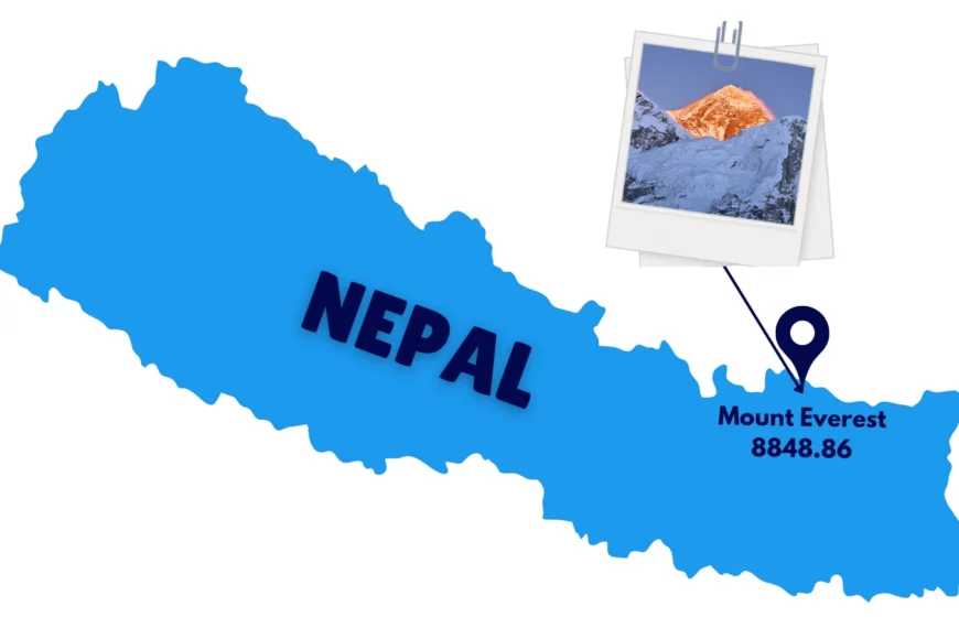
Country: Nepal
Province: Koshi Province
District: Solukhumbu
Municipality: Khumbu Pasang Lhamu Rural Municipality
National Park: Sagarmatha National Park (UNESCO World Heritage Site)
Coordinates: 27.9881° N, 86.9250° E
Nearby Peaks: Lhotse, Nuptse, Makalu
Which Country is Mount Everest Located in?
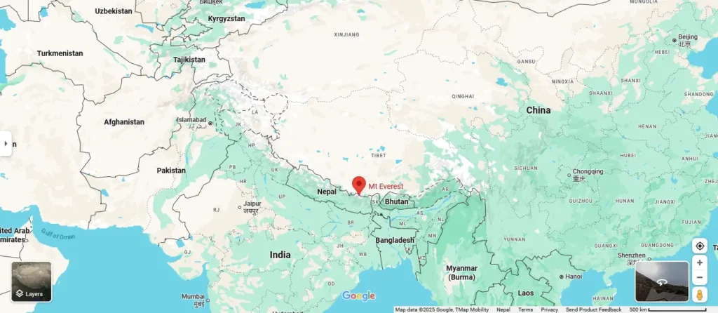
Mount Everest, the highest peak in the world, is located in Nepal. Mount Everest is located in Khumbu Pasang Lhamu Rural Municipality, in Solukhumbu District, which falls under Koshi Province. The mountain is known as “Sagarmatha” in Nepal, meaning “Forehead of the sky”. In Tibet, it is known as “Chomolungma,” meaning “Goddess of the Valley or Goddess Mother of the World.”
Mt. Everest is shared by Nepal and the Tibet Autonomous Region of China, where the northern face lies in Tibet. It holds both cultural and spiritual significance for both countries, shaping the identity of the region.
Mount Everest: Location on the World Map
Mount Everest’s location on the world map is in Nepal, in the Tibetan Himalayas.
Everest is located in South Asia, in the Himalayas. It is part of the Great Himalayas, the youngest and tallest mountain range on Earth. On a map, you’ll find Everest standing still into the northeastern region of Nepal, near the border of China’s Tibet Autonomous Region.
Geographical Location of Mount Everest
Everest lies in the heart of the Himalayas, a prime region for tectonic activity and home to several of the world’s tallest peaks. Mount Everest sits at 27.9881° N latitude and 86.9250° E longitude, placing it right in the heart of the majestic Himalayas. These exact coordinates mark it as one of the most iconic and valuable landmarks on Earth. The mountain rises from the Solukhumbu of Nepal and Tingri County of Tibet, making it a shared natural wonder for the two countries. The mountain stands as a boundary line between these two countries.
Latitude: 27.9881° N
Longitude: 86.9250° E
Continent: Asia
Is Mount Everest in Nepal or Tibet?
Mount Everest comes with a location controversy, with searches such as “Mount Everest can be approached from which two countries?” The short answer to this question is both, as this pinnacle of the planet shares an international border. But if your question changes to “Where should I go to experience Everest?”, then the answer is Nepal. The popularity of the most famous trekking and climbing routes, including the legendary Everest Base Camp trek, are located on the Nepalese (southern) side. The Tibet (northern) side receives fewer visitors due to more stringent travel regulations.
When we say Everest belongs to the Himalayas, it is to say it belongs to something greater than borders or maps. It belongs to a silence that speaks to the soul, to a wind that carries a prayer from the gently flapping prayer flags, to dreams that compel us to look up and believe in something so majestic that nature has gifted us.
Which Continent is Mount Everest Located on?
Mount Everest is located on the continent of Asia, and to be more specific, it is located on the South Asian sub-continent, which is home to countries like Nepal, India, Bhutan, Pakistan, and Bangladesh. Mount Everest, specifically, is located on the crest of the Himalayas. The mountain not only highlights the beautiful landscapes of the continent but also the deep spiritual and cultural values, the heritage holds.
Mount Everest Elevation: How tall is Mount Everest?
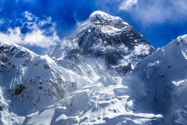
Mount Everest is the highest point on Earth at an elevation of 8848.86 metres or 29031.7 feet above sea level. The official height was confirmed by a joint survey of Nepal and China in 2020. This immense cloud reaching, height of Everest has extreme conditions where the body receives only one third of the oxygen available at sea level.
The thin-air zone near the summit is referred to as the “Death Zone,” which is more than just a location that underscores how extreme it is to be at the top of Mount Everest. Getting to the highest point on Mount Everest is not merely a test of physical endurance; it is also a measure of human will, making it one of the most respected, dangerous activities in the world of offshore mountaineering.
What Mountain Range is Everest located in?
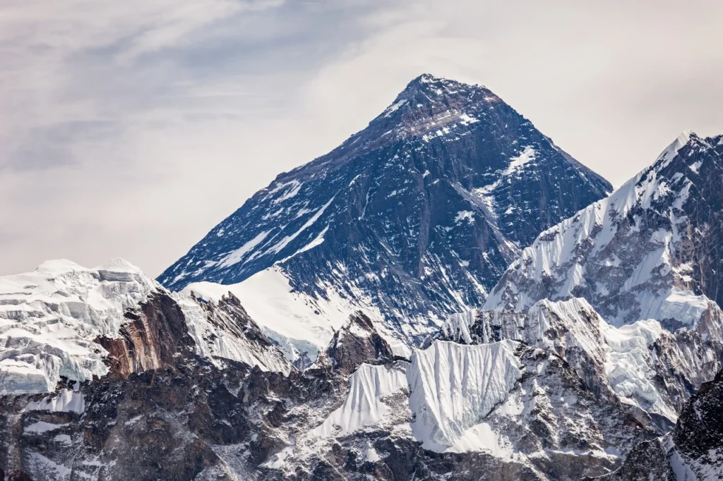
Mt. Everest rises from the heart of the Himalayas, and it is at the center of the Himalayas, the biggest and most poetic mountain range on the planet. It is officially located in the Mahalangur Himal, an incredible sub-range of giants in the eastern Himalayas, where Everest is not alone, but also accompanied by other giants such as Lhotse, Nuptse, and Makalu. The Himalayas are a vast geographical zone in Nepal, Tibet (China), India, Bhutan, and Pakistan. They are more than just a collection of peaks; they are a living representation of Earth’s power and magnificence.
Everest’s home in the Himalayan range is not just a geographical point; it is an emotional point. It is the spiritual spine of Asia and the beating heart of every adventurer who has wanted to feel small under something truly massive. Mahalangur sub-range is not only where the Earth’s highest point lies, but a land that is built of hopes and dreams, bravery, and the understated force of Nature that is truly magnificent.
Mount Everest Camp Locations: South Col and North Col
Mount Everest is about both physical endurance and mental determination. Climbers take two primary routes to reach the summit, the South Col Route (Nepal) and the North Col Route (Tibet), with the base camps on the two sides. Each route has important camps that climbers will encounter as they navigate the extremes of Mount Everest.
South Col Route (the Nepal side)
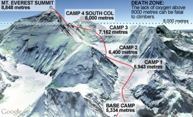
The South Col Route lies on Nepal’s side. It consists of the Everest Base Camp(5,364 m/ 17,598 ft), which is located in Khumbu Valley and is also the starting point of the Everest climb. It is also known as Mount Everest Base Camp.
After Base Camp comes Camp I(6065 m/19900 ft), which can be reached through the dangerous Khumbu Icefall, and it consists of ice ladders and snow bridges.
Camp II lies at an altitude of 6400m/21000 ft in Western Cwm Valley(pronounced Koom). This is a place where climbers stop to rest, acclimatize, and prepare for the journey upward.
Located on the Lhotse Face lies Camp III(7200m/ 23625 ft), which goes through an icy slope where climbers rely on fixed ropes and extreme weather conditions.
Camp IV- South Col(7920 m/ 26000 ft), even though it feels closer to the summit, it is where the situation is extreme. It is also known as “Death Zone” and also the last staging point before the summit push.
North Col Route(Tibet Side)
The North Col Route is on the Tibet side. It begins at North Base Camp (5,150 m), located northeast of the Rongbuk Glacier. It is isolated and less commercialized than the South Route, with haunting views and a spiritual silence.
The Intermediate Camp (~5,800 m) is the first transitional camp, where the air becomes thin and climbers begin to slow down; it is the first endurance test.
At Advanced Base Camp (6,492 m), climbers are confronted with, at times, unsheltered wind, bone-chilling cold, and continuous exposure. Eating to catch energy levels or lying down to rest are efforts to adapt.
From here, the climb to North Col / Camp I (7,010 m) is steep, full of ice, and exposed until the climber reaches a narrow, steep ridge and finally a view of the summit. The climbers finally feel that the sense of risk is becoming a reality.
Above the North Col, high camps/Camp II(7,500 m+) can be found along the Northeast Ridge, where the climbers are chasing the summit while fighting for life. Everything is slow, shallow breaths, and not easily thought. Within sight rests the infamous Second Step, which is a 40 m vertical rock wall, yet it awaits the climbers. There is a fixed ladder to assist, but it does not assist with the fear.
This route removes all ego, experience, and expectations. Only those who can understand when to push onwards or turn back have a fighting chance to return. Everest gives, and takes.
The Solukhumbu District: Nepal’s Gateway to Everest
Solukhumbu, not just the gateway but the soul of Everest, has seen it all. For questions such as “Where is Everest?” the answer is not simply coordinates; it is Solukhumbu: a place where the mountain is not only present, but alive.
Solukhumbu is almost a mythical place. It combines thin-air human experiences in sacred prayer flags that drape monasteries and blisters carved into personified glacier walls. It is a state of mind where altitude becomes attitude. Everest has been a powerful force in shaping Solukhumbu’s culture, economy, and global reputation.
The Sherpa people have made a life in this Himalayan embrace, and they represent the mountain’s traditions through guiding trekkers, managing teahouses, and rites of sanctuary. They are an enduring part of the Everest story, as are the impressions they have created in the hearts and minds of travelers.
Absolute and Relative Location of Mount Everest
The absolute location of Mount Everest in the Mahalangur Himal sub-range in the Himalayas is 27.9881° North latitude and 86.9250° East longitude. These coordinates are crucial for mapping, navigation, and scientific research, helping not just researchers and geographers but climbers and adventurers to locate the highest point on Earth.
The relative location of Mount Everest is east of Kathmandu, the capital city of Nepal.The highest mountain is near the head of the Khumbu Glacier, Solukhumbu District, surrounded by the other four famous peaks-mount Lhotse, Mount Nuptse, and Mount Makalu. The Tibetan side of Everest is accessed along the Rongbuk Glacier, close to Tingri County. Everest is deeply situated within the Sagarmatha National Park, a World Heritage Site of recognized value considering biodiversity and spiritual importance. It occupies a central spot in the Himalayas and stands out as a landmark that defines both the physical and cultural landscape of this entire region.
Mount Everest North face vs South face
The mountain is one, but it shares a border between two countries. Adding value to both countries, the mountain stands still with the South Face in Nepal and the North Face in Tibet.
| Feature | South Face (Nepal) | North Face (Tibet) |
| Famous Route | South Col Route | North East Ridge Route |
| Infrastructure and Logistics | Better support and logistics with good commercial support. | Remote and Limited Logistics with stricter permits as well as fewer expeditions. |
| Access Point | Lukla followed by the EBC Trek through Khumbu Valley. | Ronbuk Monastery, drive to North Base Camp |
| Base Camp Altitude | 5,364 m (17,598 ft) | 5,150 m (16,900 ft) |
| First Ascent | In 1953, Edmund Hillary and Tenzing Norgay Sherpa. | British Expeditions in the 1920s(Explored) by George Mallory and Andrew Irvine. |
| Key Obstacle | Khumbu Icefall, Hillary Step (collapsed in 2015) | The Second Step is very technical. |
| Altitude Challenge | Shorter time above 8,000 m (“Death Zone”) | Longer exposure to high altitude and harsher conditions |
| Road | Requires trekking through Sagarmatha National Park because no direct road access. | Direct Road Access to Base Camp. |
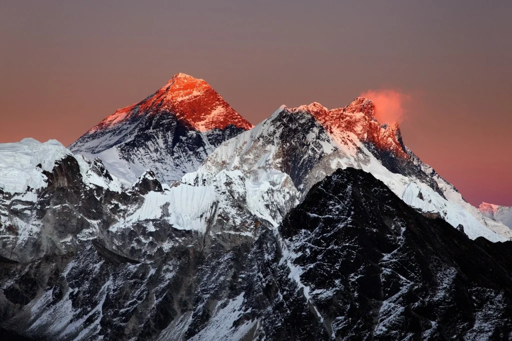
What does the North Face of Everest look like?
Unlike the culturally vibrant and popular South Face, the North Face comes in raw form with steep ridges and glaciers. It is seen from Tibet like a massive, jagged pyramid, rising straight out of the frozen land of the Tibetan Plateau. The north face is untouched, with secrets of the mountains kept safe in the glaciers and sheets of ice. Everest stands bare, harsh, and honest. The North Face offers fewer crowds and deeper silence, calling out to seasoned climbers and seekers of solitude.
From the Everest North Base Camp, beside the Rongbuk Monastery, the north face looks relatively steep and severe; it has little vegetation, but it has a remote beauty. It’s a place that attracts experienced climbers looking for a more difficult and quieter path to the top of the world.
Best View of Mount Everest
Everest, for the visitors, is all about the view. The best view of Mount Everest can be seen from different places in Nepal and Tibet. Kalapatthar near Everest Base Camp provides a close-up view with panoramic mountain views, and best if you love photography. If you want the best Everest view while sipping hot tea, then the Everest View Hotel in Syangboche is the highest-located hotel in the world with clear views of Everest from its terrace. If you are short on time, a Mount Everest scenic flight from Kathmandu or a helicopter tour to Kala Patthar offers aerial views within hours.
On the Tibet side, the Rongbuk Monastery and the North Base Camp nearby provide rare, symmetrical views of the Everest north face. Whatever the case, whether you’re trekking the Himalayas or flying above them, these are the best places for clear and dramatic views of Mount Everest.
Conclusion
Everest is not just a destination but a mirror where we return to the essence of our desires, fears, and strength. It does not matter if you stand at its base, follow it on a map, or carry it in silence within; you are for sure moved by Everest: the roof of the world. It is a bucket list of many where dreams touch the sky, and the silence speaks louder than words. The highest peak in the world, Everest, may seem still, just in one place, but it lives in the hearts of climbers, storytellers, monks, and mountain lovers from every corner of the globe.
FAQs
1. Where is Mount Everest located in the Himalayas?
Mount Everest is located in the eastern Himalayas, within the Mahalangur Himal sub-range. It rises along the border between Nepal and the Tibet Autonomous Region of China and is the highest mountain peak in this iconic range of mountains. Mount Everest is located northeast of the Solukhumbu District of Nepal and southwest of the Tingri County of Tibet.
2. Is Mount Everest located in India?
No, Mount Everest is not in India. It lies on the border between Nepal and Tibet (China) in the eastern Himalayas.
3. Is Mount Everest located in China?
Partially, Yes. Mount Everest is situated on the border between Nepal and China. Its northern face is in Tibet, which is an autonomous region of China, and the southern face is in Nepal. So Everest is shared by both countries.
4. Is Mount Everest in the Northern hemisphere?
Yes, Mount Everest is in the northern hemisphere. It is situated at around 27.99° North latitude, in the eastern Himalayas on the border between Nepal and the Tibet Autonomous Region of China.
5. Has anyone climbed the north face of Everest?
Yes, many climbers have successfully summited Everest via the north face in Tibet. The first confirmed ascent from the north was in 1960, and it remains a popular but more challenging alternative to the south route.
6. Is Mount Everest the highest point on Earth?
Yes, Mount Everest is the highest point on Earth when measured from sea level, standing at 8,848.86 meters (29,031.7 feet) tall.
7. Is Mount Everest seen from Kathmandu?
No, Mount Everest can’t be seen from Kathmandu with the naked eye; it’s too far and blocked by other mountains.
8. What is the closest city to Mount Everest?
Lukla is the closest town with an airport, and it’s the main gateway for trekkers.
9. Where is the second-highest mountain?
The second-highest mountain on Earth is K2, also known as Mount Godwin-Austen. It’s located on the border between Pakistan and China in the Karakoram Range and stands at 8,611 meters (28,251 feet) tall.
10. Who discovered Everest?
Mount Everest was first identified as the world’s highest peak in 1852 by Radhanath Sikdar, a surveyor who calculated its height using trigonometry. Locals knew the mountain long before this.