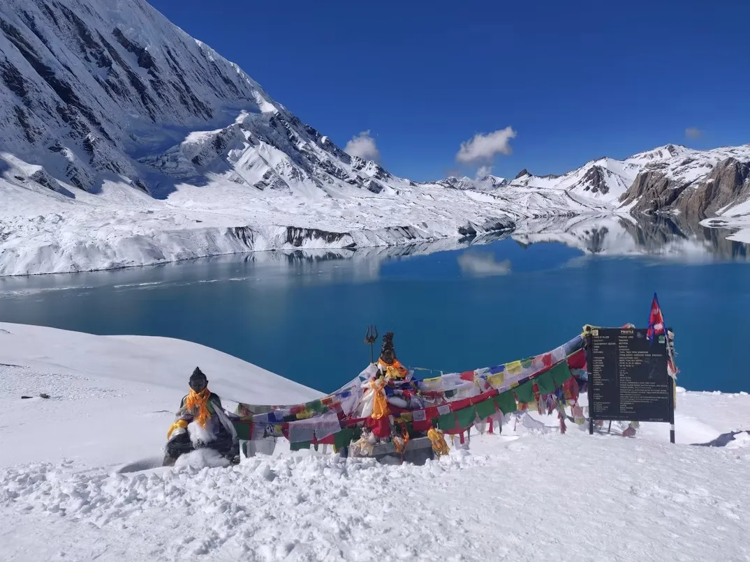
Tilicho Lake Trek Packages – Cost, Itinerary & 12, 14 & 16 Day Options – 12, 14, & 16 Days
Trip Overview
| Country | Nepal |
| Duration | 12, 14, & 16 Days |
| Difficulty | MODERATE |
| Max Altitude | Tilicho Lake – 4,919 m (12-Day) | Thorong La Pass – 5,416 m (14 & 16-Day) |
| Meals | Breakfast, Lunch & Dinner |
| Accommodation | 3-Star Hotels (Kathmandu & Pokhara) + Teahouses (on trail) |
| Best Season | March–May (Spring) & September–November (Autumn) |
Trip Highlights
Visit Tilicho Lake (4,919 m / 16,138 ft), one of the world's highest alpine lakes.
Cross the iconic Thorong La Pass (5,416 m / 17,769 ft), one of the highest trekking passes in the Himalayas (14 & 16-Day itineraries).
Explore the traditional Himalayan village of Manang, known for its Tibetan-influenced culture and stunning mountain views.
Witness panoramic views of Annapurna II, Annapurna III, Annapurna IV, Gangapurna, Tilicho Peak, Chulu Peaks, Nilgiri, and Dhaulagiri.
Trek through diverse landscapes, including subtropical forests, alpine meadows, glacial valleys, and the high-altitude deserts of Mustang.
Experience authentic hospitality while staying in traditional family-run teahouses.
Visit the sacred pilgrimage site of Muktinath Temple, revered by both Hindus and Buddhists (14 & 16-Day itineraries).
Walk through charming Himalayan villages such as Chame, Upper Pisang, Manang, Khangsar, Yak Kharka, Kagbeni, and Marpha.
Enjoy a quieter side trail to Tilicho Lake that many Annapurna Circuit trekkers miss.
Trek with experienced government-licensed local guides focused on safety, responsible tourism, and authentic cultural experiences.
Trip Description
Which Tilicho Lake Trek Should You Choose?
Choosing the right Tilicho Lake Trek itinerary depends on your available time, fitness level, and whether you want to visit Tilicho Lake only or combine it with the full Annapurna Circuit by crossing Thorong La Pass (5,416 m / 17,769 ft).
Note: The 14-Day Classic and 16-Day Extended itineraries both continue beyond Tilicho Lake to cross Thorong La Pass, making them true Annapurna Circuit with Tilicho Lake treks. The 12-Day Express itinerary focuses on reaching Tilicho Lake and returns via the same route without crossing the pass, making it the best option for trekkers with limited time.
Choose the 12-Day Tilicho Lake Trek (Express) if:
You want to reach Tilicho Lake in the shortest possible time and are not planning to cross Thorong La Pass. This itinerary retraces the route back through Manang and Chame, making it ideal for trekkers with limited time who still want to experience one of the highest lakes in the world.
Choose the 14-Day Annapurna Circuit with Tilicho Lake Trek (Classic) if:
You want the most balanced experience — visiting Tilicho Lake and completing the classic Annapurna Circuit by crossing Thorong La Pass and descending through Muktinath and Jomsom. This is our most popular combined itinerary and the best choice for most first-time trekkers.
Choose the 16-Day Annapurna Circuit with Tilicho Lake Trek (Extended) if:
You prefer a slower, more immersive journey with extra time to explore Kagbeni, Marpha (famous for its apple orchards), and Tatopani's natural hot springs after crossing Thorong La Pass.
Note: The main differences between the three itineraries are the trip duration, trekking pace, route completion, departure style, and cultural experiences. While the 12-Day Express focuses on Tilicho Lake only, the 14-Day Classic and 16-Day Extended complete the Annapurna Circuit by crossing Thorong La Pass, with the extended itinerary including additional stops in Kagbeni, Marpha, and Tatopani for a richer cultural experience.
Departure & Pricing Information: The 12-Day Express and 16-Day Extended itineraries operate as private treks, available for solo travelers or bookings of 2 or more trekkers. The displayed prices are per person based on a minimum of 2 trekkers and may vary for solo travelers or customized private treks depending on group size, travel season, accommodation preferences, and additional services. The 14-Day Classic follows scheduled group departures at a fixed per-person price but can also be arranged as a private trek upon request. Solo trekkers are welcome on all three itineraries.
Detailed Itinerary
14-Days Classic
Day 1 – Day 1: Arrival in Kathmandu (1,400 m / 4,593 ft)
| Accommodation | Hotel |
| Meals | Welcome Dinner |
Welcome to Nepal! Upon arrival at Tribhuvan International Airport, a representative from Walk Through Nepal will greet you and transfer you to your hotel in the heart of Kathmandu. After checking in, you'll have time to rest after your journey or explore the lively streets of Thamel, Kathmandu's popular tourist district known for its trekking shops, cafés, and cultural atmosphere.
In the evening, you'll meet your trekking guide for a comprehensive pre-trek briefing. During this session, your guide will walk you through the Tilicho Lake and Annapurna Circuit itinerary, review current trail and weather conditions, discuss altitude safety protocols, check your trekking equipment, and answer any last-minute questions before the adventure begins. This is also the time to flag any dietary restrictions, medical conditions, or concerns so your guide can plan accordingly.
The day concludes with a traditional Nepali welcome dinner, giving you the opportunity to sample local cuisine such as dal bhat and momos while getting to know your guide and any fellow trekkers joining the group. Although no trekking takes place today, it's the perfect opportunity to adjust to the time zone, pick up any last-minute gear from Thamel's trekking shops, and mentally prepare for the two weeks ahead. A good night's rest will set you up well for tomorrow's long scenic drive toward the Annapurna region.
Today's Highlights:
Airport pickup by the Walk Through Nepal team
Comfortable transfer to your hotel in Kathmandu
Free time to explore the vibrant streets of Thamel
Detailed trek briefing and equipment check
Traditional Nepali welcome dinner
Day 2 – Day 2: Drive from Kathmandu (1,400 m) to Chame (2,650 m / 8,694 ft)
| Ascent | 1,250 m / 4,101 ft |
| Distance | Approx. 215 km / 134 mi | |
| Duration | 9–10 hours |
| Accommodation | Teahouse |
| Meals | Breakfast, Lunch, Dinner |
After an early breakfast, you'll leave Kathmandu and begin the long but scenic drive toward the Annapurna region. The route follows the Prithvi Highway alongside the Trishuli River before turning north at Dumre toward Besisahar, the traditional starting point of the Annapurna Circuit. From here, the road narrows and climbs steadily along the Marsyangdi River Valley, winding through terraced hillsides, waterfalls, suspension bridges, and small roadside villages.
As the vehicle gains altitude past Dharapani, the vegetation shifts from subtropical farmland to cooler pine and fir forest, and your first real views of the Manang Himal begin to open up. The road itself is rough in places, this is mountain driving, not a highway, so expect a bumpy but genuinely spectacular ride, with the Marsyangdi River roaring below for much of the journey.
By late afternoon, you'll reach Chame, the administrative headquarters of Manang District, tucked beneath dramatic cliffs and cloaked in forest. Chame is a proper mountain town with a natural hot spring, a handful of good bakeries, and views of Lamjung Himal and Annapurna II framing the valley. After a long day of travel, settle into your teahouse, enjoy a hearty dinner, and get an early night, real trekking begins tomorrow, and it's worth arriving rested.
Today's Highlights:
Scenic drive along the Prithvi Highway and Marsyangdi River Valley
Pass through Besisahar and Dharapani, gateways to the Annapurna Circuit
Watch the landscape shift from subtropical valley to alpine forest
Arrive in Chame beneath Lamjung Himal and Annapurna II
Optional soak in Chame's natural hot spring
Overnight in a traditional mountain teahouse
Day 3 – Day 3: Trek from Chame (2,650 m) to Upper Pisang (3,300 m / 10,827 ft)
| Ascent | 750 m / 2,461 ft |
| Descent | 100 m / 328 ft |
| Distance | Approx. 14 km / 8.7 mi |
| Duration | 5–6 hours |
| Accommodation | Teahouse |
| Meals | Breakfast, Lunch, Dinner |
Today marks the real start of your trek. Leaving Chame, the trail follows the Marsyangdi River through dense pine, fir, and rhododendron forest, crossing several suspension bridges as the valley narrows. The path is well-graded but steadily gains elevation, and you'll begin to feel the terrain and vegetation change noticeably compared to the previous day's drive.
A short but worthwhile detour takes you past a striking curved rock formation and, on clear mornings, your first proper glimpse of Paungda Danda, a vast, smooth rock face rising directly from the valley floor that local legend says souls climb on their way to heaven. Continuing on, the trail crosses the river one final time before the valley opens up dramatically at the base of the Pisang rock face, an enormous vertical cliff that dominates the skyline as you approach the village.
Upper Pisang, perched higher on the hillside than its lower counterpart, offers a noticeably different atmosphere, narrow stone alleyways, a monastery worth a short visit, and increasingly Tibetan-influenced architecture and culture as you move deeper into the rain-shadow region. From the village, you'll get your first real, unobstructed view of Annapurna II (7,937 m), whose massive north face fills much of the horizon. Take some time in the late afternoon to walk up toward the monastery for even better views before settling in for the evening.
Today's Highlights:
Trek through pine, fir, and rhododendron forest along the Marsyangdi River
Cross multiple suspension bridges
Pass beneath the towering Pisang rock face
Spectacular views of Annapurna II (7,937 m)
Visit the monastery in Upper Pisang
Overnight in a traditional Tibetan-influenced village
Day 4 – Day 4: Trek Upper Pisang (3,300 m) to Manang (3,519 m / 11,545 ft) via Ghyaru & Ngawal
| Ascent | 650 m / 2,133 ft |
| Descent | 430 m / 1,411 ft |
| Distance | Approx. 16 km / 10 mi |
| Duration | 6–7 hours |
| Accommodation | Teahouse |
| Meals | Breakfast, Lunch, Dinner |
Today offers a choice between two routes to Manang: a shorter, flatter path through the valley floor, or the higher, more scenic route via Ghyaru and Ngawal, the route we follow, as it offers significantly better acclimatization and some of the finest mountain views on the entire trek. After crossing the Marsyangdi River, a long series of stone staircases climbs steeply to Ghyaru (3,670 m), and the effort pays off almost immediately: from the village you get an uninterrupted panorama of Annapurna II, III, IV, Gangapurna, and Pisang Peak stacked across the horizon.
From Ghyaru, the trail continues along an old trading route to Ngawal, a beautifully preserved Tibetan Buddhist village with centuries-old monasteries, mani walls, and prayer flags strung between traditional stone houses. This section of trail sees far fewer trekkers than the valley route below, giving it a quieter, more authentic feel. Take time here to look for blue sheep on the surrounding hillsides and to appreciate the strong Tibetan cultural influence that defines this upper stretch of the Manang valley.
From Ngawal, the trail descends gradually through juniper scrub and open alpine meadow, passing near Braga's dramatic cliffside monastery before the final approach into Manang. As the largest and most developed village on the circuit, Manang offers real comforts, bakeries, pool tables, even a cinema showing mountaineering documentaries, making it a welcome stop before the demanding days ahead toward Tilicho Lake.
Today's Highlights:
Steep climb to Ghyaru with sweeping Annapurna Massif views
Walk the quieter high route through Ngawal
Visit centuries-old Tibetan Buddhist monasteries
Possible sightings of blue sheep on the hillsides
Arrive in Manang, the largest village on the circuit
Day 5 – Day 5: Acclimatization Day in Manang (3,519 m) – Hike to Ice Lake (4,620 m / 15,157 ft)
| Ascent | 1,100 m / 3,609 ft |
| Descent | 1,100 m / 3,609 ft |
| Distance | Approx. 10–12 km round trip |
| Duration | 5–6 hours |
| Accommodation | Teahouse |
| Meals | Breakfast, Lunch, Dinner |
Today's acclimatization day is one of the most important on the entire trip, not a rest day in the strict sense, but an active one, following the well-established mountaineering principle of "climb high, sleep low." Given that the days ahead take you toward Tilicho Lake at nearly 4,920 m and, eventually, Thorong La Pass at 5,416 m, this hike plays a real role in reducing your risk of altitude sickness later in the trek.
After an early breakfast, the trail climbs steeply out of Manang through pine forest and open yak pasture, gaining over 1,000 meters in a relatively short distance. It's a genuinely demanding climb, and your guide will set a deliberately slow pace to help your body adjust. The reward at the top is Ice Lake (Kicho Tal), a striking alpine lake at 4,620 m surrounded by an amphitheater of peaks, Annapurna II, III, Gangapurna, Tilicho Peak, and the Chulu massif are all visible from here on a clear day.
After spending time at the lake taking photos and resting, you'll descend back to Manang for a second night at the same elevation, which is the key acclimatization benefit of the day. The afternoon and evening are yours to recover, many trekkers use the time to visit the Himalayan Rescue Association's information post, where volunteer doctors give a free daily talk on altitude sickness, or simply relax at one of Manang's famous bakeries with a coffee and apple pie before the trail leaves the main circuit route tomorrow.
Today's Highlights:
Essential acclimatization hike following "climb high, sleep low"
Reach Ice Lake (4,620 m) with panoramic Himalayan views
Views of Annapurna II, III, Gangapurna, Tilicho Peak, and the Chulu range
Optional altitude sickness talk at the Himalayan Rescue Association
Second night in Manang for proper acclimatization
Day 6 – Day 6: Trek Manang (3,519 m) to Khangsar (3,734 m / 12,251 ft)
| Ascent | 300 m / 984 ft |
| Descent | 85 m / 279 ft |
| Distance | Approx. 8 km / 5 mi |
| Duration | 3–4 hours |
| Accommodation | Teahouse |
| Meals | Breakfast, Lunch, Dinner |
Today the route leaves the main Annapurna Circuit trail behind, branching west toward Tilicho Lake, from this point on, you'll see noticeably fewer trekkers, as most continue north toward Yak Kharka and Thorong La. The relatively short, gentle day is a welcome contrast after yesterday's demanding acclimatization hike, giving your body more time to adjust before the tougher terrain ahead.
The trail climbs gradually out of Manang, crossing open grassland and skirting the edge of the valley with Gangapurna and its glacial lake visible below. As you continue west, the landscape becomes noticeably drier and more exposed. a preview of the arid, high-altitude terrain that characterizes the entire Tilicho Lake approach. Along the way, keep an eye out for the ruins of old Khangsar Fort, perched on a ridge above the trail, a reminder of the region's history as a trading route between Nepal and Tibet.
Khangsar itself is a modest but atmospheric village of traditional stone houses, and holds the distinction of being the last Nepali-speaking settlement before the high alpine wilderness beyond. From the village, you get striking views of Kang Guru Peak (6,981 m), an often-overlooked but genuinely impressive mountain that dominates the skyline to the north. This is also your last chance to stock up on any final supplies before the more basic facilities of Tilicho Base Camp, so use the afternoon to rest, hydrate, and prepare for the increasingly remote terrain ahead.
Today's Highlights:
Leave the main Annapurna Circuit trail for Tilicho Lake
Views of Gangapurna and its glacial lake
Pass the ruins of old Khangsar Fort
Reach Khangsar, the last Nepali-speaking village on the route
Views of Kang Guru Peak (6,981 m)
Day 7 – Day 7: Trek Khangsar (3,734 m) to Tilicho Base Camp (4,150 m / 13,615 ft)
| Ascent | 470 m / 1,542 ft |
| Descent | 54 m / 177 ft |
| Distance | Approx. 10 km / 6.2 mi |
| Duration | 5–6 hours |
| Accommodation | Teahouse |
| Meals | Breakfast, Lunch, Dinner |
This is one of the more technically demanding days of the trek, both physically and mentally. Leaving Khangsar, the trail climbs steadily before reaching the section trekkers refer to as the "Great Landslide", a long, narrow, exposed traverse cut across a steep, loose scree slope above the Khangsar Khola. There's no real technical difficulty involved, but the drop below is significant, the path is often only a narrow exposed trail in places, and strong winds can pick up by early afternoon, so your guide will aim to cross this section as early in the day as possible.
Beyond the landslide crossing, the trail eases somewhat, continuing along the valley with the scenery becoming increasingly stark and high-altitude, sparse vegetation, glacial moraine, and huge open views up toward Tilicho Peak (7,134 m), which now dominates the skyline ahead. Yaks are frequently seen grazing on the sparse grass that clings to the hillsides, and the silence and remoteness of this stretch is genuinely striking compared to the busier main circuit trail.
Tilicho Base Camp itself sits in a dramatic bowl directly beneath Tilicho Peak, with basic but functional teahouses serving trekkers en route to the lake. Facilities here are noticeably simpler than lower down the valley, expect colder rooms, limited electricity, and higher prices for extras like charging and hot water, so it's worth mentally preparing for a more rustic night. Rest well; tomorrow's early start to the lake is the physical highlight of the entire trek.
Today's Highlights:
Cross the dramatic, exposed "Great Landslide" section
Walk beneath Tilicho Peak (7,134 m) through stark alpine terrain
Spot yaks grazing on the high pastures
Arrive at Tilicho Base Camp, the final stop before the lake
Basic but atmospheric high-altitude teahouse stay
Day 8 – Day 8: Hike to Tilicho Lake (4,919 m), Descend to Yak Kharka (4,020 m / 13,189 ft)
| Ascent | 769 m / 2,523 ft |
| Descent | 899 m / 2,949 ft |
| Distance | Approx. 16 km / 10 mi |
| Duration | 7–8 hours |
| Accommodation | Teahouse |
| Meals | Breakfast, Lunch, Dinner |
Today is the highlight of the entire trek. You'll set off well before sunrise, as strong winds tend to pick up at the lake by mid-morning and the trail is far more pleasant, and safer, in calm early-morning conditions. The climb from Tilicho Base Camp is steep and relentless, switchbacking up loose scree and rock with the air noticeably thinner at this altitude, but the trail is well-marked and your guide will maintain a slow, steady pace throughout.
As you crest the final ridge, Tilicho Lake reveals itself all at once, a vast, glacial expanse of turquoise and deep blue water framed by the sheer walls of the Annapurna Massif and the pyramid of Tilicho Peak directly above. At 4,919 m, it's recognized as one of the highest lakes of its size in the world, and the scale of the surrounding scenery is genuinely difficult to capture in photographs. Depending on conditions, you may also spot Tilicho Peak's glaciers calving into the lake, and on clear days the reflection of the surrounding peaks on the water is spectacular.
After spending time at the lake, you'll descend back toward Base Camp and then continue further, rejoining the main Annapurna Circuit trail and continuing on to Yak Kharka to sleep. It's a genuinely long and tiring day, the single toughest of the trip in terms of total elevation change, but reaching Yak Kharka tonight keeps you on schedule for the Thorong La Pass crossing later in the itinerary.
Today's Highlights:
Reach Tilicho Lake (4,919 m), one of the world's highest lakes
Panoramic views of the Annapurna Massif and Tilicho Peak
Possible views of glacial activity feeding the lake
Rejoin the classic Annapurna Circuit trail
Longest and most physically demanding day of the trek
Day 9 – Day 9: Trek Yak Kharka (4,020 m) to Thorong Phedi (4,525 m / 14,846 ft)
| Ascent | 505 m / 1,657 ft |
| Distance | Approx. 7 km / 4.3 mi |
| Duration | 4–5 hours |
| Accommodation | Teahouse |
| Meals | Breakfast, Lunch, Dinner |
After yesterday's demanding push to Tilicho Lake, today's shorter trek gives your body a chance to recover somewhat while continuing to gain the altitude needed for tomorrow's pass crossing. The trail climbs steadily along rocky, exposed hillsides above the Marsyangdi Valley, crossing a suspension bridge before reaching the small settlement of Ledar, a popular midday rest stop with good mountain views.
Beyond Ledar, the trail becomes noticeably steeper and more rugged, traversing beneath unstable cliffs and across a section prone to rockfall, so your guide will keep a close eye on timing and conditions here. Despite the more demanding terrain, the scenery is spectacular throughout, you're now well above the treeline, surrounded by bare rock, scree, and the first real sense of true high-altitude wilderness.
Thorong Phedi, meaning "the foot of Thorong Hill," sits in a narrow, dramatic valley directly below the pass. It's a small, functional settlement with just a handful of teahouses, all fairly basic given the extreme location. This is also a good point for a final health check, your guide will assess how you're feeling and, depending on your condition and the weather forecast, may recommend a short additional hike up to High Camp (4,880 m) for extra acclimatization before returning to Phedi to sleep, or staying the night at Phedi itself. Rest as much as possible today; tomorrow requires an early, pre-dawn start.
Today's Highlights:
Trek through increasingly rugged, high-altitude terrain
Cross a suspension bridge and pass through Ledar
Reach Thorong Phedi, the final stop before Thorong La Pass
Optional acclimatization hike to High Camp
Final rest before the pass crossing
Day 10 – Day 10: Cross Thorong La Pass (5,416 m), Descend to Muktinath (3,800 m / 12,467 ft)
| Ascent | 891 m / 2,923 ft |
| Descent | 1,616 m / 5,302 ft |
| Distance | Approx. 15 km / 9.3 mi |
| Duration | 8–10 hours |
| Accommodation | Teahouse |
| Meals | Breakfast, Lunch, Dinner |
Today is the physical and emotional climax of the trek. You'll begin in the dark, typically around 4–5 a.m., climbing by headlamp to take advantage of calmer morning weather before strong winds typically pick up on the pass by early afternoon. The ascent from Thorong Phedi is steep, cold, and relentless, this is high-altitude trekking at its most demanding, but as dawn breaks over the Annapurna and Dhaulagiri ranges, the views make every step worthwhile.
Reaching the top of Thorong La Pass at 5,416 m is a genuine achievement, one of the highest trekking passes in the world, marked by a chaotic sprawl of prayer flags snapping in the wind and a small sign confirming the altitude. Take time here to celebrate, catch your breath, and take in the 360-degree panorama before the long descent begins; conditions at the top can change quickly, so your guide won't want to linger too long.
The descent is where the real physical toll of the day sets in over 1,600 meters of steep, knee-jarring downhill over loose rock and scree, dropping you from the barren high-altitude terrain into the dry, wind-carved landscape of Lower Mustang, which feels almost like a different country given the dramatic shift in climate and geography. By the time you reach Muktinath, one of Nepal's most important pilgrimage sites for both Hindus and Buddhists, most trekkers are exhausted but elated. Settle into your teahouse, and if energy allows, take a short walk to the temple complex to see its famous eternal flame and 108 sacred water spouts.
Today's Highlights:
Cross the legendary Thorong La Pass (5,416 m)
Watch sunrise over the Annapurna and Dhaulagiri ranges
Celebrate at the summit beneath the prayer flags
Descend into the dramatic, arid landscape of Lower Mustang
Arrive at the sacred pilgrimage site of Muktinath
Day 11 – Day 11: Trek Muktinath (3,800 m) to Jomsom (2,720 m / 8,924 ft) via Kagbeni
| Descent | 1,080 m / 3,543 ft |
| Distance | Approx. 16 km / 10 mi |
| Duration | 5–6 hours |
| Accommodation | Teahouse |
| Meals | Breakfast, Lunch, Dinner |
After the exertion of crossing Thorong La, today is a noticeably gentler, mostly downhill walk, a welcome change of pace. Start the morning with a proper visit to Muktinath Temple if you didn't have the energy yesterday; the complex is genuinely striking, with its 108 bull-headed water spouts, eternal natural flame, and a palpable sense of spiritual significance that draws pilgrims from across Nepal and India.
From Muktinath, the trail descends through increasingly barren, windswept terrain into the heart of Lower Mustang, with the Nilgiri and Dhaulagiri ranges dominating the horizon. You'll soon reach Kagbeni, one of the most atmospheric villages on the entire route, a maze of narrow stone alleyways, whitewashed mud-brick houses, and centuries-old monasteries that feels almost frozen in time. Kagbeni also marks the official checkpoint into Upper Mustang, the restricted region beyond, and even without continuing further, it's worth taking an hour or two to wander the village and explore its 15th-century monastery.
From Kagbeni, the trail follows the broad, windswept Kali Gandaki riverbed, one of the deepest gorges on Earth, toward Jomsom, the administrative hub of the Mustang district. The afternoon winds here are notoriously strong, funneling straight up the valley, so expect a bracing final stretch into town. Jomsom itself is a bustling little settlement with an airstrip, shops, and a noticeably different, more Tibetan-influenced feel compared to anywhere else on the trek so far.
Today's Highlights:
Visit Muktinath Temple's eternal flame and sacred water spouts
Explore the medieval walled village of Kagbeni
Walk the vast Kali Gandaki riverbed
Views of Nilgiri, Dhaulagiri, and Tukuche Peak
Arrive in the windswept town of Jomsom
Day 12 – Day 12: Drive Jomsom (2,720 m) to Pokhara (822 m / 2,697 ft)
| Descent | 1,898 m / 6,227 ft |
| Distance | Approx. 155 km / 96 mi |
| Duration | 7–8 hours |
| Accommodation | Hotel |
| Meals | Breakfast & Lunch |
Today's drive follows the Kali Gandaki Gorge, one of the deepest river gorges in the world, with Dhaulagiri (8,167 m) and Annapurna I (8,091 m) rising on either side, as you descend from the high, arid Mustang region back toward the lush mid-hills of central Nepal. The road passes through Marpha, a picturesque Thakali village famous for its apple orchards, stone-paved streets, and locally distilled apple brandy; if timing allows, this is a great spot for a short break and a taste of the local produce.
Continuing south through Tukuche, Larjung, and Ghasa, the landscape transforms dramatically over just a few hours, the barren, windswept terrain of Mustang gradually gives way to pine forest, then subtropical vegetation, then terraced farmland, as you drop nearly 1,900 meters in elevation. The road itself is rough and winding in sections, particularly through the gorge, so it's a long day of travel, but the constantly changing scenery keeps it engaging throughout.
By late afternoon, you'll arrive in Pokhara, Nepal's lakeside adventure capital and a striking contrast to the rugged mountain villages of the past two weeks. After checking into your hotel, most trekkers spend the evening simply relaxing, walking along the Lakeside promenade by Phewa Lake, enjoying a proper hot shower and a varied restaurant menu, and reflecting on what's been an extraordinary two weeks in the mountains.
Today's Highlights:
Scenic drive through the Kali Gandaki Gorge
Visit the apple-growing village of Marpha
Views of Dhaulagiri and Annapurna South
Dramatic shift from high desert to lush subtropical valley
Relax by Phewa Lake in Pokhara
Day 13 – Day 13: Drive Pokhara (822 m) to Kathmandu (1,400 m)
| Ascent | 578 m / 1,896 ft |
| Distance | Approx. 200 km / 124 mi |
| Duration | 6–7 hours |
| Accommodation | Hotel |
| Meals | Breakfast |
After breakfast, and depending on your bus schedule (or Flight Optional), an optional early-morning stroll along Phewa Lake or a boat ride out to the Tal Barahi Temple, you'll begin the drive back to Kathmandu along the Prithvi Highway, retracing much of the route from Day 2 in reverse. The road follows the Trishuli River for long stretches, winding through terraced hillsides, small roadside towns, and rural villages.
This final travel day offers a good opportunity to mentally decompress after the trek, many trekkers use the drive to look back through photos, chat with their guide about the highlights of the trip, or simply watch the Nepali countryside go by. Traffic approaching the Kathmandu Valley can add time to the journey in the late afternoon, so departure time is planned to account for this.
Upon arrival in Kathmandu, check into your hotel and spend the remainder of the day at your leisure. This is a good chance to pick up souvenirs in Thamel, pashmina scarves, singing bowls, hand-knotted rugs, and trekking gear are all widely available, or simply enjoy a proper restaurant meal after two weeks of teahouse dining. If you'd like, your guide can recommend a good spot for a farewell dinner to mark the end of the trek.
Today's Highlights:
Scenic return drive along the Trishuli River
Optional morning at Phewa Lake before departure
Free time to shop for souvenirs in Thamel
Optional farewell dinner
Final overnight stay in Kathmandu
Day 14 – Day 14: Final Departure from Kathmandu
| Meals | Breakfast |
Your 14-Day Annapurna Circuit with Tilicho Lake Trek comes to an end today. After breakfast, our team will transfer you to Tribhuvan International Airport according to your flight schedule, allowing enough buffer time for check-in and security.
As you depart Nepal, you'll take with you the memory of standing at Tilicho Lake, one of the highest lakes in the world, crossing the legendary Thorong La Pass at dawn, and experiencing the dramatic shift in landscape and culture from the lush Marsyangdi Valley to the arid highlands of Mustang. We look forward to welcoming you back to Nepal for your next Himalayan adventure.
Today's Highlights:
Airport transfer to Tribhuvan International Airport
Assistance with departure arrangements
End of your Annapurna Circuit with Tilicho Lake Trek
12-Days Express
Day 1 – Day 1: Arrival in Kathmandu (1,400 m / 4,593 ft)
| Accommodation | Hotel |
| Meals | Welcome Dinner |
Welcome to Nepal! Upon arrival at Tribhuvan International Airport, a Walk Through Nepal representative will greet you and transfer you to your hotel in Kathmandu. After checking in, relax or explore the streets of Thamel before meeting your guide for a pre-trek briefing covering the route, altitude safety, and equipment check. The evening concludes with a traditional Nepali welcome dinner.
Today's Highlights:
Airport pickup and hotel transfer
Free time to explore Thamel
Trek briefing and gear check
Traditional Nepali welcome dinner
Day 2 – Day 2: Drive from Kathmandu (1,400 m) to Chame (2,650 m / 8,694 ft)
| Distance | Approx. 215 km (134 mi) |
| Duration | 9–10 hours |
| Accommodation | Teahouse |
| Meals | Breakfast, Lunch, Dinner |
After breakfast, drive along the Prithvi Highway and Marsyangdi River Valley through Besisahar and Dharapani to Chame, the administrative headquarters of Manang District. The road climbs steadily through terraced hillsides, forested valleys, and traditional villages, offering an early introduction to the diversity of the Annapurna region.
Today's Highlights:
Scenic drive through the Marsyangdi River Valley
Pass Besisahar and Dharapani
Arrive in Chame beneath Lamjung Himal and Annapurna II
Overnight in a mountain teahouse
Day 3 – Day 3: Trek Chame (2,650 m) to Upper Pisang (3,300 m / 10,827 ft)
| Distance | Approx. 14 km (8.7 mi) |
| Duration | 5–6 hours |
| Accommodation | Teahouse |
| Meals | Breakfast, Lunch, Dinner |
The trail follows the Marsyangdi River through pine forest before crossing a suspension bridge beneath the dramatic Pisang rock face. Upper Pisang offers striking Tibetan-influenced architecture and some of the best views of Annapurna II along the entire route.
Today's Highlights:
Walk beneath the towering Pisang rock face
Views of Annapurna II (7,937 m)
Explore the Tibetan-influenced village of Upper Pisang
Day 4 – Day 4: Trek Upper Pisang (3,300 m) to Manang (3,519 m / 11,545 ft) via Ghyaru & Ngawal
| Distance | Approx. 16 km (10 mi) |
| Duration | 6–7 hours |
| Accommodation | Teahouse |
| Meals | Breakfast, Lunch, Dinner |
Taking the scenic high route via Ghyaru and Ngawal instead of the lower valley trail adds a steeper climb but delivers far better acclimatization and panoramic views of Annapurna II, III, IV, and Gangapurna. The trail passes ancient monasteries and Tibetan Buddhist villages before descending into Manang, the largest village on the circuit.
Today's Highlights:
Scenic high route via Ghyaru and Ngawal
Panoramic views of the Annapurna Massif
Arrive in Manang, the key acclimatization stop
Day 5 – Day 5: Acclimatization Day in Manang (3,519 m) – Hike to Ice Lake (4,620 m / 15,157 ft)
| Duration | 5–6 hours round trip |
| Accommodation | Teahouse |
| Meals | Breakfast, Lunch, Dinner |
Following the "climb high, sleep low" principle, hike up through yak pastures and alpine grassland to Ice Lake for sweeping views of Annapurna II, III, Gangapurna, and Tilicho Peak before descending to Manang for a second night, allowing your body to adjust before pushing higher toward Tilicho Base Camp.
Today's Highlights:
Optional acclimatization hike to Ice Lake or another nearby viewpoint
Panoramic Annapurna and Tilicho Peak views
Explore Manang's bakeries and Himalayan Rescue Association centre
Day 6 – Day 6: Trek Manang (3,519 m) to Khangsar (3,734 m / 12,251 ft)
| Distance | Approx. 8 km (5 mi) |
| Duration | 3–4 hours |
| Accommodation | Teahouse |
| Meals | Breakfast, Lunch, Dinner |
Leaving the main Annapurna Circuit trail, the route branches west toward Khangsar, the last Nepali-speaking village before the high alpine terrain surrounding Tilicho Lake. Traditional stone houses and views of Kang Guru Peak (6,981 m) mark this short but scenic day.
Today's Highlights:
Leave the main circuit trail toward Tilicho Lake
Traditional stone architecture of Khangsar
Views of Kang Guru Peak
Day 7 – Day 7: Trek Khangsar (3,734 m) to Tilicho Base Camp (4,150 m / 13,615 ft)
| Distance | Approx. 10 km (6.2 mi) |
| Duration | 5–6 hours |
| Accommodation | Teahouse |
| Meals | Breakfast, Lunch, Dinner |
The trail narrows considerably after Khangsar, crossing an exposed, landslide-prone section along the Khangsar Khola known locally as the "Great Landslide" before reaching Tilicho Base Camp, set directly below Tilicho Peak.
Today's Highlights:
Cross the dramatic landslide section above the Khangsar Khola
Arrive at Tilicho Base Camp beneath Tilicho Peak (7,134 m)
Prepare for tomorrow's hike to the lake
Day 8 – Day 8: Hike to Tilicho Lake (4,919 m / 16,138 ft) and Return to Tilicho Base Camp
| Duration | 7–8 hours round trip |
| Accommodation | Teahouse |
| Meals | Breakfast, Lunch, Dinner |
An early start takes you up a steep, exposed trail to Tilicho Lake, one of the highest lakes in the world. Surrounded by the Annapurna Massif and Tilicho Peak, the lake's colour shifts through shades of turquoise and deep blue depending on the light. After spending time at the lake, descend back to Tilicho Base Camp for the night.
Today's Highlights:
Reach Tilicho Lake, one of the world's highest lakes
360-degree views of Tilicho Peak, Annapurna I, and the Chulu peaks
Return to Tilicho Base Camp for overnight
Day 9 – Day 9: Trek Tilicho Base Camp (4,150 m) to Manang (3,519 m)
| Distance | Approx. 18 km (11 mi) |
| Duration | 4–5 hours |
| Accommodation | Teahouse |
| Meals | Breakfast, Lunch, Dinner |
Retrace the route back through Khangsar to Manang, descending steadily with continued views of the Annapurna range. The lower altitude and easier terrain make this a comfortable recovery day after the demanding push to the lake.
Today's Highlights:
Descend back through Khangsar to Manang
Comfortable recovery day
Final night in Manang village
Day 10 – Day 10: Trek/Jeep Manang (3,519 m) to Chame (2,650 m)
| Distance | Approx. 20 km (12.4 mi) |
| Duration | 6–7 hours (trek) or approx. 3 hours (jeep) |
| Accommodation | Teahouse |
| Meals | Breakfast, Lunch, Dinner |
Continue down the Marsyangdi Valley on foot, or arrange a local jeep for a shorter, more comfortable descent to Chame, passing back through Upper Pisang and the villages visited on the way up.
Today's Highlights:
Descend through the Marsyangdi Valley
Optional local jeep for a shorter day
Overnight in Chame
Day 11 – Day 11: Drive Chame (2,650 m) to Kathmandu (1,400 m)
| Distance | Approx. 215 km (134 mi) |
| Duration | 9–10 hours |
| Accommodation | Hotel |
| Meals | Breakfast |
After breakfast, drive back to Kathmandu via Besisahar and the Prithvi Highway. Upon arrival, check into your hotel and spend the evening at leisure — shopping for souvenirs or relaxing in Thamel after completing the trek.
Today's Highlights:
Scenic drive back to Kathmandu
Free evening in Thamel
Overnight in Kathmandu
Day 12 – Day 12: Final Departure from Kathmandu
Your 12-Day Tilicho Lake Trek with Walk Through Nepal comes to an end today. After breakfast, our team will transfer you to Tribhuvan International Airport according to your flight schedule.
Today's Highlights:
Airport transfer to Tribhuvan International Airport
Assistance with departure arrangements
End of your Tilicho Lake Trek Nepal
16-Days Extended
Day 1 – Day 1: Arrival in Kathmandu (1,400 m / 4,593 ft)
| Accommodation | Hotel |
| Meals | Welcome Dinner |
Welcome to Nepal! Upon arrival at Tribhuvan International Airport, a representative from Walk Through Nepal will greet you and transfer you to your hotel in the heart of Kathmandu. After checking in, you'll have time to rest after your journey or explore the lively streets of Thamel, Kathmandu's popular tourist district known for its trekking shops, cafés, and cultural atmosphere.
In the evening, you'll meet your trekking guide for a comprehensive pre-trek briefing. During this session, your guide will walk you through the full 16-day itinerary, review current trail and weather conditions along both the classic circuit route and the Tilicho Lake side trip, discuss altitude safety protocols, check your trekking equipment, and answer any last-minute questions before the adventure begins. This is also the time to flag any dietary restrictions, medical conditions, or concerns so your guide can plan accordingly.
The day concludes with a traditional Nepali welcome dinner, giving you the opportunity to sample local cuisine such as dal bhat and momos while getting to know your guide and any fellow trekkers joining the group. Although no trekking takes place today, it's the perfect opportunity to adjust to the time zone, pick up any last-minute gear from Thamel's trekking shops, and mentally prepare for the sixteen days ahead. A good night's rest will set you up well for tomorrow's long scenic drive toward the Annapurna region.
Today's Highlights:
Airport pickup by the Walk Through Nepal team
Comfortable transfer to your hotel in Kathmandu
Free time to explore the vibrant streets of Thamel
Detailed trek briefing and equipment check
Traditional Nepali welcome dinner
Day 2 – Day 2: Drive from Kathmandu (1,400 m / 4,593 ft) to Bhulbhule/Ngadi (840 m / 2,756 ft)
| Distance | Approx. 180–190 km / 112–118 mi |
| Duration | 7–8 hours |
| Accommodation | Teahouse |
| Meals | Breakfast, Lunch, Dinner |
After an early breakfast, you'll leave Kathmandu and begin the long drive west along the Prithvi Highway, following the Trishuli River through terraced hillsides and small roadside towns before turning north at Dumre toward Besisahar, the traditional gateway to the Annapurna Circuit. From Besisahar, the road narrows into a rougher, more rural track that winds along the Marsyangdi River Valley, passing rice paddies, millet fields, and Gurung villages perched on the hillsides above.
By afternoon you'll reach Bhulbhule or Ngadi, two small trailhead villages sitting at the true starting point of the classic Annapurna Circuit trek. Despite the modest elevation, the setting already feels distinctly different from the Kathmandu Valley, the Marsyangdi River runs fast and loud below the village, and the first forested foothills of the Annapurna region rise steeply on either side. Settle into your teahouse, enjoy dinner, and rest well, as the real trekking begins tomorrow.
Today's Highlights:
Scenic drive along the Prithvi Highway and Marsyangdi River Valley
Pass through Besisahar, gateway to the Annapurna Circuit
Arrive at Bhulbhule/Ngadi, the traditional trailhead of the circuit
First views of the forested Annapurna foothills
Overnight beside the roaring Marsyangdi River
Day 3 – Day 3: Trek Bhulbhule (840 m) to Jagat/Chamje (1,410 m / 4,626 ft)
| Ascent | 570 m / 1,870 ft |
| Distance | Approx. 15–16 km / 9.3–10 mi |
| Duration | 5–6 hours |
| Accommodation | Teahouse |
| Meals | Breakfast, Lunch, Dinner |
Leaving Bhulbhule, the trail crosses a long suspension bridge over the Marsyangdi River and begins its steady climb north through subtropical forest, terraced farmland, and a series of small Gurung and Magar villages. Waterfalls tumble down the hillsides in several places, and the trail crosses the river back and forth multiple times on swaying suspension bridges as the valley narrows.
Passing through Bahundanda, a ridge-top village with sweeping views back down the valley, the trail descends briefly before climbing again toward Jagat, a stone-paved village that historically served as a customs checkpoint on the old trade route to Tibet. Chamje, a short distance further, sits beside a dramatic waterfall and offers a slightly quieter overnight option. Either village provides your first real taste of traditional Annapurna Circuit trekking life, with stone houses, prayer flags, and terraced fields climbing the hillsides above.
Today's Highlights:
Cross multiple suspension bridges over the Marsyangdi River
Pass through the Gurung village of Bahundanda
Visit the historic trade-route checkpoint village of Jagat
Views of waterfalls cascading down forested hillsides
Overnight in a traditional stone-built village
Day 4 – Day 4: Trek Jagat (1,410 m) to Dharapani (1,960 m / 6,430 ft)
| Ascent | 550 m / 1,804 ft |
| Distance | Approx. 15 km / 9.3 mi |
| Duration | 5–6 hours |
| Accommodation | Teahouse |
| Meals | Breakfast, Lunch, Dinner |
The trail continues north through a steep, forested gorge, crossing back and forth over the Marsyangdi River on high suspension bridges. Past Chamje, the valley narrows dramatically, and the path climbs through dense forest before opening out near Tal, a wide, flat village sitting beside a broad sandy riverbank and a spectacular waterfall, a striking contrast to the tight gorge just passed through.
Beyond Tal, the trail enters Manang District, and the architecture and culture begin to shift noticeably, with flatter-roofed stone houses and an increasingly Tibetan Buddhist influence replacing the Gurung-style villages seen lower down. Dharapani, a small but well-established village at the junction with the Nar-Phu trail, makes for a comfortable overnight stop, with mani walls and chortens marking the trail's entry into the higher Manang valley.
Today's Highlights:
Trek through a dramatic forested gorge along the Marsyangdi River
Visit Tal, with its wide riverbank and waterfall
Cross into Manang District
Notice the shift toward Tibetan Buddhist architecture and culture
Overnight in Dharapani, junction point for the Nar-Phu trail
Day 5 – Day 5: Trek Dharapani (1,960 m) to Chame (2,650 m / 8,690 ft)
| Ascent | 710 m / 2,329 ft |
| Distance | Approx. 15 km / 9.3 mi |
| Duration | 5–6 hours |
| Accommodation | Teahouse |
| Meals | Breakfast, Lunch, Dinner |
Today's trail climbs steadily through fir, pine, and rhododendron forest, following the Marsyangdi River deeper into the mountains. The valley narrows and steepens, and the vegetation shifts noticeably as you gain elevation, with cooler alpine forest replacing the subtropical growth of the lower valley. Along the way, the trail passes several small settlements and mani walls, with occasional glimpses of snow-capped peaks appearing through gaps in the forest canopy.
By afternoon you'll reach Chame, the administrative headquarters of Manang District, set beneath dramatic cliffs and framed by views of Lamjung Himal and Annapurna II. Chame is a proper mountain town, with a natural hot spring, a handful of bakeries, and a noticeably more developed feel than the villages passed through over the previous three days. It's a good place to rest, pick up any last supplies, and prepare for the higher terrain ahead.
Today's Highlights:
Climb through pine, fir, and rhododendron forest
Follow the Marsyangdi River deeper into the mountains
First proper views of Lamjung Himal and Annapurna II
Arrive in Chame, Manang District's administrative center
Optional soak in Chame's natural hot spring
Day 6 – Day 6: Trek Chame (2,650 m / 8,690 ft) to Upper Pisang (3,300 m / 10,827 ft)
| Ascent | 630 m / 2,067 ft |
| Distance | Approx. 14 km / 8.7 mi |
| Duration | 5–6 hours |
| Accommodation | Teahouse |
| Meals | Breakfast, Lunch, Dinner |
Leaving Chame, the trail follows the Marsyangdi River through dense forest, crossing several suspension bridges as the valley narrows further. A short detour offers views of a striking curved rock formation and, on clear mornings, your first proper glimpse of Paungda Danda, the vast smooth rock face rising directly from the valley floor.
The trail crosses the river a final time before the valley opens dramatically at the base of the Pisang rock face, an enormous vertical cliff dominating the skyline as you approach the village. Upper Pisang, set higher on the hillside, offers narrow stone alleyways, a small monastery, and increasingly Tibetan-influenced architecture, along with your first unobstructed view of Annapurna II's massive north face.
Today's Highlights:
Trek along the Marsyangdi River through pine and rhododendron forest
Pass beneath the towering Pisang rock face
Spectacular views of Annapurna II (7,937 m)
Visit the monastery in Upper Pisang
Overnight in a traditional Tibetan-influenced village
Day 7 – Day 7: Trek Upper Pisang (3,300 m) to Manang (3,519 m / 11,545 ft) via Ngawal
| Ascent | 610 m / 2,001 ft |
| Descent | 370 m / 1,214 ft |
| Distance | Approx. 16 km / 10 mi |
| Duration | 6 hours |
| Accommodation | Teahouse |
| Meals | Breakfast, Lunch, Dinner |
Today's route takes the higher, more scenic path via Ghyaru and Ngawal rather than the flatter valley trail, offering significantly better acclimatization and some of the finest mountain views on the entire trek. A steep series of stone staircases climbs to Ghyaru, rewarding the effort with an uninterrupted panorama of Annapurna II, III, IV, Gangapurna, and Pisang Peak.
From Ghyaru, the trail continues to Ngawal, a beautifully preserved Tibetan Buddhist village with centuries-old monasteries, mani walls, and prayer flags. This upper route sees far fewer trekkers than the valley path below, giving it a quieter, more authentic feel. From Ngawal, the trail descends gradually through juniper scrub and open alpine meadow, passing near Braga's cliffside monastery before the final approach into Manang, the largest and most developed village on the circuit.
Today's Highlights:
Steep climb to Ghyaru with sweeping Annapurna Massif views
Walk the quieter high route through Ngawal
Visit centuries-old Tibetan Buddhist monasteries
Possible sightings of blue sheep on the hillsides
Arrive in Manang, the largest village on the circuit
Day 8 – Day 8: Acclimatization Day in Manang (3,519 m / 11,545 ft) – Hike to Ice Lake (4,620 m / 15,157 ft)
| Ascent | 1,080 m / 3,543 ft |
| Descent | 1,080 m / 3,543 ft |
| Distance | Approx. 10–12 km round trip |
| Duration | 5–6 hours |
| Accommodation | Teahouse |
| Meals | Breakfast, Lunch, Dinner |
Today's acclimatization day is essential, not a rest day in the strict sense but an active one, following the mountaineering principle of "climb high, sleep low." With Tilicho Lake and Thorong La Pass still ahead, this hike plays a genuine role in reducing the risk of altitude sickness later in the trek.
The trail climbs steeply out of Manang through pine forest and open yak pasture, gaining over 1,000 meters to reach Ice Lake (Kicho Tal), a striking alpine lake surrounded by an amphitheater of peaks, Annapurna II, III, Gangapurna, Tilicho Peak, and the Chulu massif are all visible on a clear day. After resting at the lake, you'll descend back to Manang for a second night at the same elevation. The afternoon is free to visit the Himalayan Rescue Association's daily altitude sickness talk or relax at one of Manang's bakeries before the trail leaves the main circuit route tomorrow.
Today's Highlights:
Essential acclimatization hike following "climb high, sleep low"
Reach Ice Lake (4,620 m) with panoramic Himalayan views
Views of Annapurna II, III, Gangapurna, Tilicho Peak, and the Chulu range
Optional altitude sickness talk at the Himalayan Rescue Association
Second night in Manang for proper acclimatization
Day 9 – Day 9: Trek Manang (3,519 m / 11,545 ft) to Khangsar (3,734 m / 12,251 ft)
| Ascent | 300 m / 984 ft |
| Descent | 106 m / 348 ft |
| Distance | Approx. 8 km / 5 mi |
| Duration | 3–4 hours |
| Accommodation | Teahouse |
| Meals | Breakfast, Lunch, Dinner |
Today the route leaves the main Annapurna Circuit trail behind, branching west toward Tilicho Lake. The relatively short, gentle day gives your body more time to adjust before the tougher terrain ahead. The trail climbs gradually out of Manang across open grassland, with Gangapurna and its glacial lake visible below, and the landscape becoming noticeably drier and more exposed.
Along the way, keep an eye out for the ruins of old Khangsar Fort, perched above the trail. Khangsar itself is a modest, atmospheric village of stone houses, and holds the distinction of being the last Nepali-speaking settlement before the high alpine wilderness beyond, with striking views of Kang Guru Peak (6,981 m) from the village.
Today's Highlights:
Leave the main Annapurna Circuit trail for Tilicho Lake
Views of Gangapurna and its glacial lake
Pass the ruins of old Khangsar Fort
Reach Khangsar, the last Nepali-speaking village on the route
Views of Kang Guru Peak (6,981 m)
Day 10 – Day 10: Trek Khangsar (3,734 m) to Tilicho Base Camp (4,150 m / 13,615 ft)
| Ascent | 470 m / 1,542 ft |
| Descent | 54 m / 177 ft |
| Distance | Approx. 10 km / 6.2 mi |
| Duration | 5–6 hours |
| Accommodation | Teahouse |
| Meals | Breakfast, Lunch, Dinner |
This is one of the more demanding days of the trek, both physically and mentally. Leaving Khangsar, the trail climbs before reaching the "Great Landslide," a long, narrow, exposed traverse cut across a steep scree slope above the Khangsar Khola. There's no technical difficulty involved, but the drop below is significant and winds can pick up by early afternoon, so this section is crossed as early as possible.
Beyond the landslide, the trail eases as the scenery becomes increasingly stark and high-altitude, with huge open views up toward Tilicho Peak (7,134 m). Yaks are frequently seen grazing on the sparse hillside grass. Tilicho Base Camp sits in a dramatic bowl directly beneath the peak, with basic but functional teahouses, expect colder rooms and higher prices for extras like charging and hot water.
Today's Highlights:
Cross the dramatic, exposed "Great Landslide" section
Walk beneath Tilicho Peak (7,134 m) through stark alpine terrain
Spot yaks grazing on the high pastures
Arrive at Tilicho Base Camp, the final stop before the lake
Basic but atmospheric high-altitude teahouse stay
Day 11 – Day 11: Hike to Tilicho Lake (4,919 m), Descend to Yak Kharka (4,020 m / 13,189 ft)
| Ascent | 769 m / 2,523 ft |
| Descent | 899 m / 2,949 ft |
| Distance | Approx. 16 km / 10 mi |
| Duration | 7–8 hours |
| Accommodation | Teahouse |
| Meals | Breakfast, Lunch, Dinner |
Today is the highlight of the entire trek. You'll set off well before sunrise, as winds tend to pick up at the lake by mid-morning. The climb from Tilicho Base Camp is steep and relentless, switchbacking up loose scree with the air noticeably thinner at this altitude, but the trail is well-marked and the pace deliberately slow.
As you crest the final ridge, Tilicho Lake reveals itself all at once, a vast glacial expanse of turquoise and deep blue water framed by the Annapurna Massif and the pyramid of Tilicho Peak. At 4,919 m, it's recognized as one of the highest lakes of its size in the world. After spending time at the lake, you'll descend back toward Base Camp and continue on, rejoining the main Annapurna Circuit trail and reaching Yak Kharka to sleep, the single toughest day of the trip in terms of total elevation change, but one that keeps you on schedule for the Thorong La crossing ahead.
Today's Highlights:
Reach Tilicho Lake (4,919 m), one of the world's highest lakes
Panoramic views of the Annapurna Massif and Tilicho Peak
Possible views of glacial activity feeding the lake
Rejoin the classic Annapurna Circuit trail
Longest and most physically demanding day of the trek
Day 12 – Day 12: Trek Yak Kharka (4,020 m) to Thorong Phedi/High Camp (4,800–4,925 m / 15,748–16,158 ft)
| Ascent | 780–905 m / 2,559–2,969 ft |
| Distance | Approx. 7–9 km / 4.3–5.6 mi |
| Duration | 4–5 hours |
| Accommodation | Teahouse |
| Meals | Breakfast, Lunch, Dinner |
After yesterday's demanding push to Tilicho Lake, today's shorter trek allows some recovery while continuing to gain the altitude needed for tomorrow's pass crossing. The trail climbs along rocky, exposed hillsides above the Marsyangdi Valley, crossing a suspension bridge before reaching Ledar, a popular midday rest stop.
Beyond Ledar, the trail becomes steeper and more rugged, traversing beneath cliffs prone to rockfall, so timing and conditions are watched closely here. Reaching Thorong Phedi, "the foot of Thorong Hill," your guide will assess how you're feeling and, depending on condition and weather, may recommend pushing on to High Camp (4,880 m) for extra acclimatization ahead of tomorrow's early start, or staying the night at Phedi itself.
Today's Highlights:
Trek through increasingly rugged, high-altitude terrain
Cross a suspension bridge and pass through Ledar
Reach Thorong Phedi, the final staging point before Thorong La
Optional push to High Camp for extra acclimatization
Final rest before the pass crossing
Day 13 – Day 13: Cross Thorong La Pass (5,416 m), Descend to Muktinath (3,800 m / 12,467 ft)
| Ascent | 491–616 m / 1,610–2,021 ft |
| Descent | 1,616 m / 5,302 ft |
| Distance | Approx. 15 km / 9.3 mi |
| Duration | 7–8 hours |
| Accommodation | Teahouse |
| Meals | Breakfast, Lunch, Dinner |
Today is the physical and emotional climax of the trek. You'll begin in the dark, typically around 4–5 a.m., climbing by headlamp to take advantage of calmer morning weather before winds pick up by early afternoon. The ascent is steep, cold, and relentless, but as dawn breaks over the Annapurna and Dhaulagiri ranges, the views make every step worthwhile.
Reaching the top of Thorong La Pass at 5,416 m, one of the highest trekking passes in the world, is a genuine achievement, marked by a sprawl of prayer flags and a small altitude sign. The descent that follows is where the real physical toll sets in: over 1,600 meters of steep, knee-jarring downhill, dropping you into the dry, wind-carved landscape of Lower Mustang. By the time you reach Muktinath, one of Nepal's most important pilgrimage sites, most trekkers are exhausted but elated.
Today's Highlights:
Cross the legendary Thorong La Pass (5,416 m)
Watch sunrise over the Annapurna and Dhaulagiri ranges
Celebrate at the summit beneath the prayer flags
Descend into the dramatic, arid landscape of Lower Mustang
Arrive at the sacred pilgrimage site of Muktinath
Day 14 – Day 14: Drive/Fly Muktinath (3,800 m) to Jomsom (2,720 m) to Pokhara (820 m / 2,690 ft)
| Descent | 2,980 m / 9,777 ft |
| Duration | 5–6 hours |
| Accommodation | Hotel |
| Meals | Breakfast, Lunch, Dinner |
Start the morning with a visit to Muktinath Temple, with its 108 sacred water spouts and eternal flame, before a short drive down the Kali Gandaki Valley to Jomsom, passing through Kagbeni and the windswept riverbed for which this stretch is known. "Enjoy a comfortable ground drive through the Kali Gandaki Gorge and Marpha back to Pokhara, fully included in your itinerary. Prefer to fly? You can upgrade to a short flight over the Annapurna and Dhaulagiri mountain ranges for an additional cost.
By the time you arrive in Pokhara, Nepal's lakeside adventure capital, the contrast with the rugged mountain villages of the past two weeks is striking. Check into your hotel and spend the evening relaxing along the Lakeside promenade by Phewa Lake, enjoying a hot shower and a proper restaurant meal.
Today's Highlights:
Visit Muktinath Temple's eternal flame and sacred water spouts
Drive through Kagbeni and the Kali Gandaki riverbed
Scenic drive (or scenic flight - available at an additional cost) from Jomsom to Pokhara
Views of the Annapurna and Dhaulagiri ranges en route
Relax by Phewa Lake in Pokhara
Day 15 – Day 15: Drive/Fly Pokhara (820 m) to Kathmandu (1,400 m / 4,593 ft) + Leisure
| Duration | 6–7 hours |
| Accommodation | Hotel |
| Meals | Breakfast |
Depending on your preference and schedule, return to Kathmandu either by a scenic 25-minute domestic flight or by a 6–7 hour drive along the Prithvi Highway, retracing much of the route from Day 2 in reverse and following the Trishuli River for long stretches. Those flying can enjoy a free morning at leisure in Pokhara, an optional boat ride on Phewa Lake out to the Tal Barahi Temple is a popular way to spend it.
Upon arrival in Kathmandu, check into your hotel and spend the remainder of the day at leisure. This is a good chance to shop for souvenirs in Thamel, pashmina scarves, singing bowls, and trekking gear are all widely available, or enjoy a proper restaurant meal after two weeks of teahouse dining. Your guide can recommend a good spot for a farewell dinner to mark the end of the trek.
Today's Highlights:
Scenic drive (or scenic flight - available at an additional cost) from Pokhara to Kathmandu
Optional morning at Phewa Lake before departure
Free time to shop for souvenirs in Thamel
Optional farewell dinner
Final overnight stay in Kathmandu
Day 16 – Day 16: Final Departure from Kathmandu
| Duration | 30–45 minutes |
| Meals | Breakfast |
Your 16-Day Annapurna Circuit with Tilicho Lake Trek Nepal comes to an end today. After breakfast, our team will transfer you to Tribhuvan International Airport according to your flight schedule, allowing enough buffer time for check-in and security.
As you depart Nepal, you'll take with you the memory of standing at Tilicho Lake, one of the highest lakes in the world, crossing the legendary Thorong La Pass at dawn, and experiencing the full sweep of the classic Annapurna Circuit from Bhulbhule's subtropical foothills to the arid highlands of Mustang. We look forward to welcoming you back to Nepal for your next Himalayan adventure.
Today's Highlights:
Airport transfer to Tribhuvan International Airport
Assistance with departure arrangements
End of your Annapurna Circuit with Tilicho Lake Trek
Price Includes
Private vehicle airport pickup and drop-off at Tribhuvan International Airport for your international arrival and departure
Kathmandu hotel accommodation in a comfortable 3-star hotel with breakfast included — 2 nights for the 12-Day and 14-Day itineraries and 3 nights for the 16-Day itinerary
Pokhara hotel accommodation in a comfortable 3-star hotel with breakfast included — 1 night for the 14-Day and 16-Day itineraries
All ground transportation outlined in the itinerary by tourist bus, private vehicle, or local jeep
Comfortable teahouse accommodation throughout the trek, based on twin sharing
Three meals daily during the trek — breakfast, lunch, and dinner, selected from local teahouse menus
A government-licensed, English-speaking trekking guide with extensive experience in the Annapurna region and first-aid training
Experienced porters to carry your luggage — 1 porter shared between every 2 trekkers, with a maximum combined luggage weight of 20 kg
Porter wages, insurance, meals, accommodation, and necessary equipment covered by the company
Annapurna Conservation Area Permit (ACAP) and all other required trekking permits
Comprehensive first-aid kit carried by your trekking guide throughout the trek
Walk Through Nepal duffel bag for use during the trek, returned after the trip if required
Welcome dinner in Kathmandu featuring authentic Nepali cuisine
All applicable government taxes, local tourism fees, and official service charges
Price Excludes
International airfare to and from Nepal.
Nepal entry visa fees (available on arrival at Tribhuvan International Airport).
Travel insurance (mandatory) covering high-altitude trekking up to 5,500 m, including emergency helicopter evacuation, medical treatment, and trip interruption.
Lunch and dinner in Kathmandu and Pokhara (except the complimentary welcome dinner).
Personal trekking equipment and clothing.
Additional porter services beyond the standard allocation.
Hot showers, Wi-Fi, battery charging, laundry services, and other personal expenses at teahouses.
Alcoholic beverages, soft drinks, bottled water, snacks, and desserts.
Tips and gratuities for guides, porters, and drivers (customary but entirely at your discretion).
Expenses resulting from itinerary changes caused by weather conditions, natural disasters, road closures, flight cancellations (if applicable), illness, or other circumstances beyond our control.
Emergency rescue, evacuation, or medical expenses not covered by your travel insurance.
Any items or services not specifically mentioned under "Cost Includes."
Trip Map
Tilicho Lake Trek Route Map
The Tilicho Lake Trek follows one of the most scenic routes in Nepal's Annapurna Conservation Area, combining the classic Annapurna Circuit with a breathtaking side trip to Tilicho Lake (4,919 m / 16,138 ft). The journey begins with an overland drive from Kathmandu to Chame/Bhulbhule, then gradually ascends through traditional Gurung and Manangi villages, dense forests, alpine valleys, and dramatic mountain landscapes before reaching the turquoise waters of Tilicho Lake.
The 14-Day Classic and 16-Day Extended itineraries continue beyond Tilicho Lake to cross the legendary Thorong La Pass (5,416 m / 17,769 ft) before descending to Muktinath, Jomsom, and Pokhara, completing the iconic Annapurna Circuit. The 12-Day Express itinerary returns via the same route after visiting Tilicho Lake, making it an excellent option for trekkers with limited time.
14-Day Tilicho Lake Trek Distance, Duration & Altitude Chart
The Tilicho Lake Trek covers approximately 140–170 km, depending on the itinerary and return route. The table below outlines the standard 14-Day Annapurna Circuit with Tilicho Lake Trek, including approximate elevations, walking distances, and trekking times for each stage.
Note: Daily walking distances become more demanding above 3,500 m, where thinner air significantly reduces hiking speed. Our itineraries are designed with gradual altitude gain and dedicated acclimatization to help minimize the risk of altitude sickness.
Route | Elevation | Distance | Walking Time |
Kathmandu → Bhulbhule → Chame (Drive) | 1,400 m → 840 m → 2,650 m | — | 9–10 hrs |
Chame → Upper Pisang | 2,650 m → 3,300 m | 13–15 km | 5–6 hrs |
Upper Pisang → Manang | 3,300 m → 3,519 m | 16–18 km | 6–7 hrs |
Manang (Acclimatization) | Hike to Ice Lake (4,620 m) | 8–10 km | 4–6 hrs |
Manang → Tilicho Base Camp | 3,519 m → 4,150 m | 13–15 km | 5–6 hrs |
Tilicho Base Camp → Tilicho Lake → Yak Kharka | 4,150 m → 4,919 m → 4,050 m | 16–18 km | 7–9 hrs |
Yak Kharka → Thorong Phedi | 4,050 m → 4,540 m | 7–8 km | 3–4 hrs |
Thorong Phedi → Thorong La Pass → Muktinath | 4,540 m → 5,416 m → 3,800 m | 15–17 km | 7–9 hrs |
Muktinath → Jomsom | 3,800 m → 2,720 m | 20–22 km (or drive) | 6–7 hrs |
Jomsom → Pokhara | 2,720 m → 822 m | — | Flight or 7–9 hrs drive |
Major Stops Along the Trail
Bhulbhule: The traditional starting point of the Annapurna Circuit, located beside the Marsyangdi River and reached by road from Kathmandu.
Chame: The administrative headquarters of Manang District, surrounded by pine forests and spectacular views of Lamjung Himal and Annapurna II.
Upper Pisang: A beautiful Himalayan village offering panoramic mountain views and traditional Tibetan-influenced culture.
Manang: The region's main acclimatization hub at 3,519 m, featuring monasteries, bakeries, mountain museums, and stunning views of Gangapurna, Annapurna III, and surrounding peaks.
Tilicho Base Camp: The final overnight stop before reaching Tilicho Lake, set beneath dramatic cliffs and rugged alpine terrain.
Tilicho Lake: At 4,919 m, Tilicho Lake is one of the world's highest alpine lakes and the highlight of the trek, renowned for its crystal-clear turquoise water and spectacular mountain setting.
Thorong La Pass: At 5,416 m, Thorong La is one of Nepal's highest trekking passes and the highest point of the 14-Day and 16-Day itineraries.
Muktinath: A sacred pilgrimage destination for both Hindus and Buddhists, famous for its eternal flame temple and spiritual significance.
Jomsom: The administrative center of Mustang, known for its strong winds, apple orchards, and dramatic Kali Gandaki Valley.
Classic Route vs Alternative Routes
The 14-Day Classic Annapurna Circuit with Tilicho Lake Trek is our most popular itinerary, offering the ideal balance of acclimatization, trekking pace, and cultural experiences while visiting both Tilicho Lake and Thorong La Pass.
We also offer two alternative itineraries to suit different travel styles:
12-Day Tilicho Lake Trek (Express)
Perfect for trekkers with limited time who want to visit Tilicho Lake without crossing Thorong La Pass. This itinerary returns to Chame via the same route after visiting the lake, reducing the overall trekking duration.
16-Day Annapurna Circuit with Tilicho Lake Trek (Extended)
Designed for trekkers who prefer a slower pace and additional cultural experiences. After crossing Thorong La Pass, the route continues through Kagbeni, Marpha, and Tatopani, providing extra time to explore traditional Himalayan villages, apple orchards, and natural hot springs before returning to Pokhara.
Altitude Profile
Frequently Asked Questions
What is the Tilicho Lake Trek?
The Tilicho Lake Trek is a spectacular Himalayan adventure in Nepal's Annapurna region that takes you to Tilicho Lake (4,919 m / 16,138 ft), one of the world's highest alpine lakes. Depending on your itinerary, the trek can also include crossing Thorong La Pass (5,416 m) as part of the classic Annapurna Circuit.
Where is Tilicho Lake located?
Tilicho Lake is located in Nepal's Manang District within the Annapurna Conservation Area. The lake lies at an elevation of 4,919 m (16,138 ft) beneath Tilicho Peak and is reached via a scenic side trail from the Annapurna Circuit.
How many days does the Tilicho Lake Trek take?
Walk Through Nepal offers 12-Day Express, 14-Day Classic, and 16-Day Extended itineraries. The best option depends on your fitness level, available time, and whether you want to cross Thorong La Pass.
What is the maximum altitude of the Tilicho Lake Trek?
The highest point depends on your itinerary. The 12-Day Express reaches Tilicho Lake (4,919 m), while the 14-Day and 16-Day itineraries continue over Thorong La Pass (5,416 m / 17,769 ft), the highest point of the trek.
Is Tilicho Lake one of the highest lakes in the world?
Yes. At 4,919 m (16,138 ft), Tilicho Lake is widely recognized as one of the world's highest alpine lakes and is one of Nepal's most iconic high-altitude trekking destinations.
What makes the Tilicho Lake Trek special?
The trek combines stunning mountain scenery, traditional Himalayan villages, and the unforgettable experience of visiting Tilicho Lake. The longer itineraries also include Thorong La Pass, making it one of Nepal's most rewarding trekking adventures.
Can I combine Tilicho Lake with the Annapurna Circuit?
Yes. Our 14-Day Classic and 16-Day Extended itineraries combine the Tilicho Lake side trip with the classic Annapurna Circuit, allowing you to experience both Tilicho Lake and Thorong La Pass in one trek.
Which Tilicho Lake Trek itinerary is best?
The 14-Day Classic is our most recommended itinerary. It offers the ideal balance of acclimatization, scenery, trekking pace, and value while including both Tilicho Lake and Thorong La Pass.
How difficult is the Tilicho Lake Trek?
The Tilicho Lake Trek is rated moderate to challenging. Trekkers walk 5–8 hours daily over varied terrain while reaching elevations above 4,900 m, making good physical fitness essential.
Can beginners do the Tilicho Lake Trek?
Yes. Beginners with good fitness, proper preparation, and a well-paced itinerary can successfully complete the trek. The 14-Day Classic is generally the best option for first-time high-altitude trekkers.
How fit do I need to be?
You should be comfortable walking 5–8 hours a day on consecutive days while carrying a light daypack. Regular hiking, stair climbing, cycling, or cardio training for several weeks before the trek is highly recommended.
How many hours do you walk each day?
Most trekking days involve 5 to 8 hours of walking, depending on the itinerary and trail conditions. Summit days to Tilicho Lake and Thorong La Pass are typically the longest.
Is the Tilicho Lake Trek harder than Annapurna Base Camp?
Yes. The Tilicho Lake Trek is generally more challenging because it reaches much higher elevations and often includes crossing Thorong La Pass, requiring better acclimatization and endurance than the Annapurna Base Camp Trek.
Which is harder: Everest Base Camp or Tilicho Lake Trek?
Both are challenging, but the Tilicho Lake Trek with Thorong La Pass is often considered slightly more demanding due to its higher maximum altitude and the long pass crossing. Everest Base Camp involves longer trekking days but a slightly lower highest point.
Do I need previous trekking experience?
Previous trekking experience is helpful but not essential. With proper preparation, a reasonable fitness level, and guidance from our experienced team, many first-time trekkers successfully complete the Tilicho Lake Trek.
Is altitude sickness common on the Tilicho Lake Trek?
Because the trek reaches nearly 5,000–5,400 meters, altitude sickness is a possibility for anyone, regardless of age or fitness. Our itineraries include gradual ascent and acclimatization days to minimize the risk.
How do you acclimatize during the trek?
Our itineraries include gradual altitude gain, a dedicated acclimatization day in Manang, and the recommended "climb high, sleep low" strategy. Your guide will also monitor your health throughout the trek.
What are the symptoms of Acute Mountain Sickness (AMS)?
Common symptoms include headache, nausea, dizziness, fatigue, loss of appetite, and difficulty sleeping. If symptoms worsen, your guide will recommend descending immediately and arrange further assistance if necessary.
What happens if I get altitude sickness?
Your guide will assess your condition and decide whether rest, medication, or descent is required. In serious cases, emergency helicopter evacuation can be arranged if covered by your travel insurance.
Is emergency helicopter evacuation available?
Yes. Helicopter evacuation is available in the event of a medical emergency or severe altitude sickness. Comprehensive travel insurance covering high-altitude helicopter rescue is mandatory for all trekkers joining the Tilicho Lake Trek.
How much does the Tilicho Lake Trek cost?
The cost depends on your chosen itinerary. At Walk Through Nepal, prices start from USD 1,699 for the 12-Day Express, USD 1,899 for the 14-Day Classic, and USD 2,099 for the 16-Day Extended package. All prices are transparent, with no hidden fees.
What is included in the package price?
Our packages include accommodation, meals during the trek, an experienced licensed guide, porter service, ground transportation, required permits, airport transfers, and government taxes. Please refer to the Cost Includes section for the complete list.
Are there any hidden costs?
No. We believe in transparent pricing. However, personal expenses such as hot showers, Wi-Fi, battery charging, drinks, laundry, travel insurance, and guide or porter tips are not included.
Can I book the Tilicho Lake Trek as a solo traveler?
Yes. Solo trekkers are welcome, and we offer guaranteed departures without requiring a minimum group size. You can join a group departure or request a private trek.
Do you offer private or customized treks?
Absolutely. We can customize your itinerary, departure date, pace, accommodation, and transportation to suit your schedule, fitness level, and travel preferences.
What type of accommodation is available during the trek?
You'll stay in comfortable 3-star hotels in Kathmandu and Pokhara, while the trek itself features traditional family-run teahouses. Rooms are generally twin-sharing, with more basic facilities at higher elevations.
Are meals included during the trek?
Yes. Breakfast, lunch, and dinner are included throughout the trekking portion of your journey. Teahouses serve a variety of Nepali, Tibetan, and basic Western dishes prepared fresh each day.
Are vegetarian or vegan meals available?
Yes. Most teahouses offer vegetarian meals, and vegan options are available in many locations. Please let us know your dietary requirements before the trek so we can assist you throughout the journey.
Is drinking water available on the trek?
Yes. Safe drinking water is available at teahouses through boiled water or refill stations. We recommend carrying a reusable bottle and using water purification tablets or a portable filter to reduce plastic waste.
Can I take a hot shower during the trek?
Yes, hot showers are available in many villages for an additional charge. Availability becomes more limited at higher elevations, and services depend on local electricity or solar power.
How do I get to the Tilicho Lake Trek starting point?
The trek begins with a scenic drive from Kathmandu to Bhulbhule or Dharapani, depending on your itinerary. All transportation is arranged by Walk Through Nepal.
Where does the trek end?
The 12-Day Express itinerary concludes after returning from Tilicho Lake, while the 14-Day and 16-Day itineraries continue over Thorong La Pass before finishing at Muktinath and returning via Jomsom and Pokhara.
Is Wi-Fi available during the trek?
Yes, Wi-Fi is available in most villages for an additional fee. However, internet speeds become slower and less reliable as you gain altitude, particularly near Tilicho Base Camp.
Can I charge my phone and camera?
Yes. Most teahouses provide charging facilities for an additional fee. We recommend bringing a power bank, as electricity may be limited at higher elevations.
Are ATMs available along the route?
Reliable ATMs are available in Kathmandu, Pokhara, and Besisahar. Beyond these areas, ATM access is limited, so it's best to carry enough Nepali Rupees for personal expenses before starting the trek.
What should I pack for the Tilicho Lake Trek?
Pack layered clothing, waterproof trekking boots, a warm sleeping bag, trekking poles, sun protection, personal medications, and travel documents. A detailed packing checklist is included in this guide to help you prepare.
Can I rent trekking gear in Kathmandu?
Yes. Kathmandu has many reputable trekking gear rental shops where you can hire down jackets, sleeping bags, trekking poles, duffel bags, and other essential equipment at affordable prices.
How much luggage can the porter carry?
One porter is provided for every two trekkers and carries a maximum combined load of 20 kg. You'll only need to carry a lightweight daypack with your daily essentials.
What kind of travel insurance do I need?
Your travel insurance must cover high-altitude trekking up to at least 5,500 meters, emergency helicopter evacuation, medical treatment, and rescue expenses. Proof of insurance is required before the trek begins.
Why should I book the Tilicho Lake Trek with Walk Through Nepal?
Walk Through Nepal combines experienced local guides, transparent pricing, ethical porter practices, carefully planned itineraries, and personalized service to deliver a safe and memorable trekking experience. From arrival to departure, our team is committed to providing reliable support and authentic Himalayan adventures.
Contact Us
Walk Through Nepal
New Road -11, Pokhara, Kaski, Nepal
Phone: +977-9856085151
Email: info@walkthroughnepal.com
Hours: Sun - Fri: 9AM - 6PM, Sat: Closed