Contents
Yes, most Nepal treks remain safe and genuinely rewarding during monsoon, with lush green hillsides, waterfalls at full force, and far fewer crowds on the trail than in peak season. The real work is choosing the right region for the month you're traveling, since flood and landslide exposure varies sharply by route, altitude, and river system, while rain-shadow destinations like Upper Mustang and Upper Dolpo stay dry and clear through the entire season.
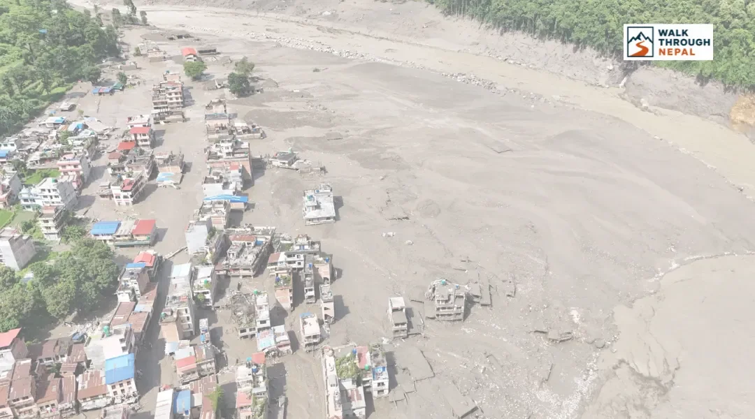
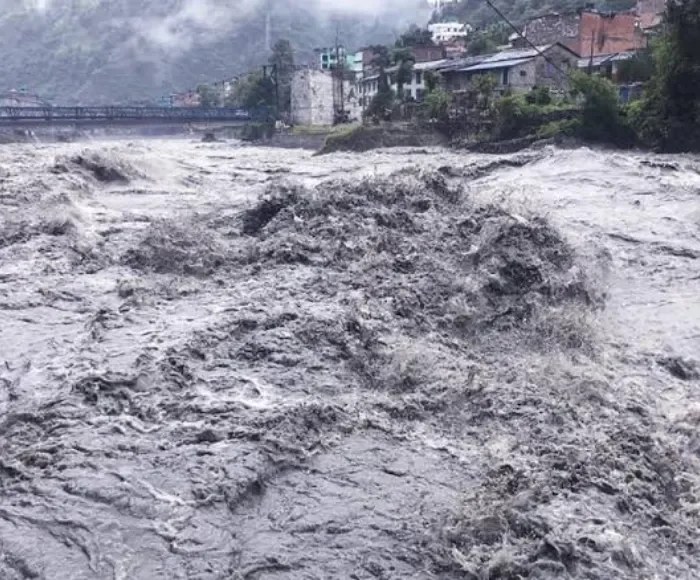
We've had a wave of messages from trekkers this week asking whether Nepal is still safe to visit, and we want to answer that honestly and directly rather than talk around it. On the morning of August 26, 2026, a flash flood came down the Bhote Koshi gorge on the Nepal-Tibet border after an ice-and-rock avalanche dammed a tributary called the Lhende Khola and then gave way. Reuters reported the flood the morning it happened, and the confirmed toll has continued rising through later Reuters and HuffPost coverage and CNN's live updates, which you can follow directly for the current figures rather than relying on a number that will already be out of date by the time you read this. Our thoughts are with everyone affected, and with the rescue teams still working the Rasuwa district right now.
We're including it here because it's a real, current example of exactly the kind of hazard this guide explains, not because it should define how you think about a Nepal trek in general. This event is centered on one border corridor in one district. The vast majority of Nepal's trekking trails, from the Annapurna foothills to the high desert of Upper Mustang, are completely unaffected and open as normal. Knowing the difference between "one valley had a bad week" and "the whole country is unsafe" is exactly what lets you plan a trip with confidence instead of canceling out of caution you don't actually need.
This guide walks through what flash floods, landslides, and glacial lake outburst floods (GLOFs) actually are, which regions carry more exposure to them and which don't, how to read the warning signs if you're ever near a river during heavy rain, and which routes are the smart, low-drama picks for a monsoon trip. We've linked directly to the government agencies, wire services, and research bodies behind the facts below, so you can check them yourself and follow them for live updates.
The Bhote Koshi Flood of August 2026
On the morning of August 26, 2026, a flash flood tore down the Bhote Koshi gorge on the Nepal-Tibet border, near Rasuwagadhi. The trigger was an ice-and-rock avalanche that dammed a tributary called the Lhende Khola; when that debris dam gave way, the released water surged downstream with almost no warning.
The flood struck the Syabrubesi access corridor, the trailhead town for the Langtang Valley trek, and it followed a rough decade for this same river system. It's the same corridor that lost the Nepal-China Friendship Bridge to an outburst flood in July 2025, on top of lasting damage from the 2015 earthquake.
As of this writing, the higher trail sections between Syabrubesi and Kyanjin Gompa (3,870 meters) haven't been confirmed damaged. The immediate concern is the access road and the border-area bridges near Rasuwagadhi, not the alpine trail itself, and that's an important distinction if you're planning a Langtang trip in the coming months.
Why Are Flash Floods Dangerous for Trekkers in Nepal?
Flash floods are worth understanding, not fearing, because knowing how they form is most of what keeps you safe around one. They're dangerous mainly because they arrive fast, sometimes rising by several meters in under 10 minutes in a narrow gorge, which is different from the slow, predictable river rise you'd see in flatter terrain.
Sudden water-level changes: A river that looks calm at 8 a.m. can surge without a corresponding rainstorm overhead, because the trigger is often upstream, sometimes across the border in Tibet, as was the case in the August 26 event.
Narrow Himalayan valleys: Trails frequently run alongside the river with steep rock walls on the other side, so the smart move is knowing in advance where the higher ground is, not discovering it in the moment.
River crossings: Suspension bridges and log crossings are the most exposed points on any trek, which is exactly why guides treat crossing timing as a daily decision rather than a fixed itinerary item.
Landslide-dammed rivers: A landslide or avalanche upstream can temporarily block a river, then release all at once when the debris dam fails. This is what triggered the August 2026 disaster, according to preliminary assessments reported by Reuters.
Glacial lake outburst floods (GLOFs): High-altitude glacial lakes held back by loose ice or moraine can breach suddenly, sending water and debris down the valley below, sometimes with no rain at all. The International Centre for Integrated Mountain Development (ICIMOD) tracks these events across the Hindu Kush Himalaya region and is a good resource if you want to go deeper on the science.
Which Trekking Areas Are More Exposed to Flood and Landslide Risks, and Which Are Calmer?
Most of Nepal's trekking network sits well away from the highest-risk corridors. Exposure concentrates in a handful of glacier-fed valleys near the Tibet border, while plenty of excellent routes, especially in the rain shadow, see very little of it.
Region | Key river system | Typical exposure | Recent context |
|---|---|---|---|
Langtang | Bhote Koshi / Trishuli | Higher, especially the Syabrubesi access corridor | Directly affected by the August 26, 2026 flash flood at Rasuwagadhi |
Manaslu | Budhi Gandaki | Moderate | Occasional landslide sections between Nyak and Prok |
Annapurna | Marsyangdi / Modi Khola | Moderate, and easing where old trekking trails avoid the road | Road-building has added some slope instability |
Lower Mustang | Kali Gandaki | Lower to moderate | Wide, open valley floor for most of its length |
Upper Mustang / Upper Dolpo | Kali Gandaki headwaters / Thuli Bheri | Lowest overall | Sit largely in the Himalayan rain shadow |
Langtang is in the news right now because the flood struck the approach corridor through Syabrubesi, the trailhead town for the Langtang Valley trek. The Bhote Koshi corridor has had a rough decade, with damage from the 2015 earthquake, a July 2025 outburst flood that destroyed the Nepal-China Friendship Bridge (reported at the time by AP News), and now this latest event. The good news is that, as of this writing, there's no confirmed damage to the higher trail sections between Syabrubesi and Kyanjin Gompa (3,870 meters). The access road and border-area bridges are the immediate concern, not the alpine trail itself, and that distinction matters a lot for anyone planning ahead.
Manaslu and the connecting Tsum Valley route see occasional, smaller-scale landslide activity around Nyak and Prok most monsoons, and local crews generally have sections reopened within days.
Annapurna routes that follow the older trekking trail, rather than the jeep road, tend to be more stable and, as a bonus, quieter and more scenic too.
Lower Mustang, from Jomsom down to Tatopani, sits in a wide, drier valley for most of its length and is a solid shoulder-season option.
Is It Safe to Trek Nepal During Monsoon?
Trekking in Nepal during monsoon, roughly June through September, is not only possible, it's genuinely one of the best-kept secrets in Himalayan travel. Trails are quieter, the hills turn a deep green, rhododendron and wildflower blooms linger longer at mid-altitude, and teahouses that are booked solid in October have space to spare. The trade-off is wetter trails, a higher chance of a short flight delay, and the occasional closed road, all of which are manageable with the right route and a flexible schedule.
Rainfall is heaviest in the eastern and central hills and lighter in the trans-Himalayan north. Trail conditions turn muddy and leech-heavy below roughly 3,000 meters, while higher alpine sections often stay drier since most of the moisture is wrung out of the clouds before reaching that altitude. Road access to trailheads like Syabrubesi, Besisahar, and Machha Khola can be interrupted for hours or days after heavy rain, and domestic flights to hill airstrips, including the Lukla route via Manthali Airport in Ramechhap, see more frequent weather delays than in peak season. Nepal's Department of Hydrology and Meteorology (DHM) is the official source for river warning levels and rainfall forecasts, and it's worth bookmarking directly if you're trekking during monsoon. The route you pick matters far more than the season itself: a Langtang or Annapurna trek during a heavy rain week looks very different from an Upper Mustang trek the same week, and choosing well is most of the battle.
How Can Trekkers Recognize Flash-Flood Risk?
None of this requires special training, just a bit of attention near rivers during heavy rain. Guides and locals read these signs automatically, and you can too.
Rapidly rising water at the river's edge, even without visible rain falling on you at that moment
Unusual river sounds, a low rumble or roar that's louder or different from the river's normal flow
Sudden muddy or discolored water, which usually means a landslide, avalanche, or debris surge has entered the system upstream
Debris in the water, branches, logs, or mud carried at a pace faster than the river was moving minutes earlier
Heavy rainfall upstream, reported by guides, locals, or visible dark clouds building over the valley above you
Landslide activity, fresh scarring on slopes, falling rocks, or cracking sounds from the hillside
What Should You Do If a Flash Flood Happens While Trekking?
If a flash flood happens near you, the response is simple and it works: move to higher ground and give the water room. Trekkers and locals get through these events safely all the time by following exactly this.
Move away from the river. Don't wait to see how high it rises, move first, assess second.
Get to higher ground, ideally a slope well above the valley floor, not just the nearest small rise.
Don't attempt to cross swollen rivers. Even 30 centimeters of fast-moving water can knock an adult off their feet.
Don't head back down right after the first surge. Flash floods often come in a few waves as upstream debris dams release in sequence.
Follow your guide and local authorities. They read river behavior far better than a first-time visitor can, and that's exactly what you're paying for.
Do a headcount before moving further, and agree on a meeting point in case the group gets separated.
How Guides Help You Trek Nepal Safely, Even in Monsoon
A good local guide is the single biggest reason monsoon trekking in Nepal works as well as it does. They're reading conditions your itinerary alone can't show you: which side trail avoids the worst river exposure, whether yesterday's rain upstream changes today's crossing, and when it's simply worth waiting an extra hour for the water to drop.
Guides check both official DHM forecasts and the kind of local knowledge that only comes from years on the same trail. They reassess route conditions each morning rather than sticking rigidly to a fixed itinerary, make the call on whether a river crossing is safe that day, stay in touch with district authorities and teahouse networks, and know the alternative routes a map alone won't show you. This is also why Nepal's 2026 regulations require a licensed guide on all major and restricted-area treks, capped at a 1:7 guide-to-trekker ratio in restricted regions like Manaslu, Upper Mustang, and Dolpo. It's a rule that works in your favor.
How to Prepare for a Monsoon Trek in Nepal
A little extra preparation is really all it takes to trek comfortably and safely through monsoon. None of this is complicated, it's mostly about keeping gear dry, staying informed, and building a little slack into your schedule.
Waterproof backpack protection, a rain cover plus dry bags for electronics and documents, not just a jacket
Appropriate footwear with real grip, broken in before the trip, since wet rock and mud punish new boots
Rain gear, a proper waterproof shell rather than a cheap poncho that tears on the first thorn bush
Power bank, since teahouse charging is unreliable during storms and often carries an extra 200 to 700 NPR fee per charge
Offline maps downloaded before you lose signal, so you always know where the higher ground is
Travel insurance that explicitly covers high-altitude emergency helicopter evacuation, not just standard medical coverage
Emergency contacts for your agency, the nearest district office, and a family contact back home, written down on paper as a backup
Extra buffer days, at minimum 1 to 2 days, so a single closed road doesn't wreck your entire trip
For live river and rainfall warnings before and during your trek, check Nepal's DHM flood forecasting division directly, and for broader disaster updates, Nepal's National Disaster Risk Reduction and Management Authority (NDRRMA) publishes rescue and relief coordination updates during active events.
Should You Cancel Your Trek Because of Flood Risk?
In most cases, no, and it's worth resisting the instinct to cancel a whole trip over one news story. Whether to adjust plans depends on the specific region you're heading to, not the country as a whole.
Don't make decisions based on one headline. The Bhote Koshi disaster is serious and real, but it's centered on one border corridor in one district, not a nationwide closure.
Check the specific trekking region you've booked, not a general news search for "Nepal flood."
Follow official warnings from DHM and NDRRMA.
Ask your trekking agency about current trail conditions. A good agency will tell you honestly if your specific route is affected, even if it costs them a booking.
Postpone only if authorities or guides actually advise against travel, and treat that advice as the final word, not the news cycle.
Which Treks Are Better During Nepal's Monsoon?
If you want a monsoon trek with essentially none of the drama above, Nepal's rain-shadow regions are the answer. Upper Mustang and Upper Dolpo see meaningfully less rainfall because the Annapurna and Dhaulagiri ranges block most of the moisture before it reaches them, which makes them two of the most dependable, and most underrated, trekking destinations in the country during summer.
Upper Mustang, reaching Lo Manthang at roughly 3,840 meters, stays comparatively dry through July and August, with clear high-desert landscapes that plenty of trekkers actually prefer to the cloud-covered views of peak season elsewhere. Upper Dolpo, home to Shey Phoksundo Lake and passes well above 5,000 meters, sees similarly reduced rainfall and a genuine sense of having the trail to yourself.
Rain shadow doesn't mean zero risk, and both regions still cross rivers and see the occasional storm cell, so the same guide, weather monitoring, and general good sense apply here as anywhere else in the Himalaya. Both are also restricted areas, meaning you'll need a Restricted Area Permit and a licensed guide regardless of group size under the current 2026 rules, which, as covered above, is a genuine safety net rather than red tape.
Frequently Asked Questions
Are Nepal treks safe during monsoon?
Yes, on most routes. Rain-shadow regions like Upper Mustang and Upper Dolpo are especially reliable, while river-valley routes closer to the Tibet border, like Langtang, carry higher seasonal risk and are worth checking against current conditions before departure.
Can flash floods happen while trekking in Nepal?
Yes, though they're concentrated in specific glacier-fed river valleys rather than spread evenly across the country. They can occur with little to no local rainfall, often triggered by a glacial lake outburst or a landslide-dammed river releasing upstream, as happened on August 26, 2026.
What should I do if a river suddenly rises?
Move away from the riverbank and toward higher ground right away. Don't attempt to cross, and wait for your guide or local authorities to confirm it's safe before returning to the trail.
Which Nepal treks are most affected by monsoon?
Langtang, Manaslu, and parts of the Annapurna region see the most rainfall, trail mud, and landslide activity, since they sit directly in the path of the monsoon's moisture from the south.
Is Upper Mustang safe during monsoon?
It's one of the most reliable monsoon options in the country, since it sits in the Himalayan rain shadow. A Restricted Area Permit and licensed guide are still required, and normal river and weather precautions still apply.
What is a GLOF?
A glacial lake outburst flood (GLOF) happens when a lake formed by glacial meltwater breaches its natural ice or moraine dam, releasing a sudden surge of water and debris down the valley below. See Wikipedia's GLOF entry for a technical overview, and ICIMOD publishes ongoing regional research on the topic.
Should I trek Nepal in August?
Absolutely, if you pick the right route. August sits in the heart of monsoon, so river-valley treks in the central and eastern hills carry more risk, while rain-shadow routes like Upper Mustang and Upper Dolpo are excellent choices this time of year.
How much warning do trekkers typically get before a flash flood?
Often only a few minutes, which is exactly why reading warning signs like sudden muddy water or a change in river sound matters more than waiting for an official alert.
Do all Nepal treks require a guide in 2026?
Yes, and it's genuinely a good thing. Current regulations require a licensed guide on all major trekking routes, and restricted areas like Manaslu, Upper Mustang, and Dolpo cap the guide-to-trekker ratio at 1:7.
What insurance do I need for a monsoon trek?
Standard travel insurance isn't enough. Look for a policy that explicitly covers high-altitude emergency helicopter evacuation and treatment for altitude-related illness, which is also required to obtain a Restricted Area Permit.
Will my flight to Lukla or another hill airstrip be affected by monsoon weather?
Flights to mountain airstrips are more prone to delay during monsoon due to low cloud cover. Building 1 to 2 buffer days into your itinerary is the standard, easy way to absorb these delays without stress.
Is the Langtang trekking trail closed after the August 2026 flood?
As of this writing, the higher trail sections haven't been confirmed damaged, though the access road and bridges near Syabrubesi and Rasuwagadhi were seriously affected, and the situation is still developing. Confirm current status with your trekking agency, and check the DHM before departure.