Contents
The Annapurna Circuit loops around the entire Annapurna massif, running from the green river valleys of the Marsyangdi up over Thorong La Pass at 5,416 meters, then dropping into the dry, Tibetan-influenced landscapes of Mustang. On current itineraries the trekking begins at Dharapani (1,860 m) after a drive from Kathmandu through Besisahar, and finishes near Jomsom (2,720 m) before heading to Pokhara.
The route splits into a few clear geographic sections: the Marsyangdi Valley, the high-altitude climb toward the pass, the Thorong La crossing, and the Mustang and Kali Gandaki descent. Because roads and itinerary lengths vary, the exact route depends on your package and how you handle transport. This guide maps the whole thing out so you know exactly where you're going.
Annapurna Circuit Trek Route at a Glance
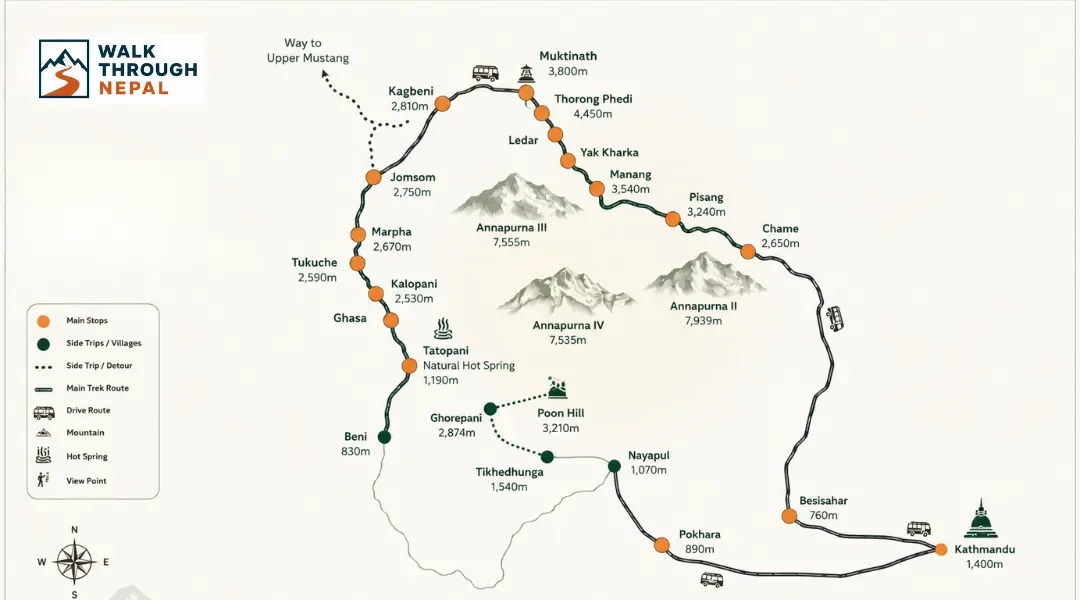
The core route runs: Dharapani → Chame → Pisang → Manang → Yak Kharka → Thorong Phedi → Thorong La Pass → Muktinath → Kagbeni → Jomsom → Pokhara. The current trekking package begins with a drive from Kathmandu to Dharapani, passing through Besisahar. Besisahar is now part of the road access route rather than the main walking route.
That distinction matters. Older descriptions of the circuit started the walk at Besisahar, adding several days of low-altitude walking that is now mostly driven. When you read an itinerary, check whether the trek walks from Besisahar or drives to Dharapani first.
Route Section | Main Places |
Marsyangdi Valley | Dharapani → Chame → Pisang → Manang |
High-altitude section | Manang → Yak Kharka → Thorong Phedi |
Thorong La crossing | Thorong Phedi → Thorong La → Muktinath |
Mustang section | Muktinath → Kagbeni → Jomsom |
Return | Jomsom → Pokhara |
Annapurna Circuit Trek Map
The Annapurna Circuit map shows a horseshoe-shaped route wrapping around the Annapurna range, starting in the Marsyangdi Valley in the east and ending in the Kali Gandaki Valley to the west. Between them sits the single crossing point over the mountains: Thorong La Pass. The map also marks major road sections in the lower valleys.
What Does the Annapurna Circuit Map Show?
A good route map lays out the trekking start point at Dharapani, the arc around the Annapurna massif, and the key villages of Chame, Pisang, and Manang. It marks Thorong La Pass (5,416 m), the pilgrimage site at Muktinath, the historic village of Kagbeni, and the transport hub of Jomsom leading to Pokhara. It also shows the elevation progression and which lower sections now have road access.
How to Follow the Annapurna Circuit Route on the Map
The easiest way to read the map is by geographic zone rather than by day.
1. Marsyangdi Valley: Dharapani → Chame → Pisang → Manang. This is the green, forested ascent following the Marsyangdi River upstream.
2. High Mountain Section: Manang → Yak Kharka → Thorong Phedi → Thorong La. This is the thin-air climb toward the pass, where the landscape turns bare and alpine.
3. Mustang / Kali Gandaki Section: Thorong La → Muktinath → Kagbeni → Jomsom. This is the dry, wind-carved descent into Lower Mustang.
4. Return to Pokhara: Jomsom → Pokhara, using the Kali Gandaki corridor by road or air.
Where Does the Annapurna Circuit Trek Start and End?
On current packages, the trek starts at Dharapani after a road drive from Kathmandu and ends near Jomsom before transferring to Pokhara. There is genuine confusion around this because the route has changed as roads have expanded, so the answer depends on which itinerary you book.
Where Does the Annapurna Circuit Start?
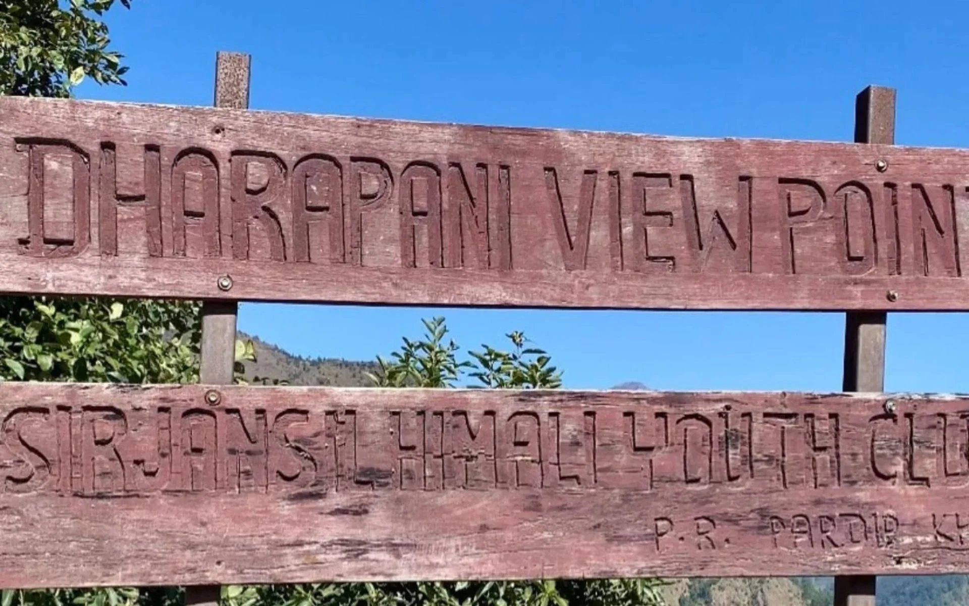
Traditionally the circuit began at Besisahar and the lower Marsyangdi region, adding days of low-altitude walking. On the current trekking package, Dharapani (1,860 m) is the trekking start point, reached by driving from Kathmandu through Besisahar. This trims off the dusty, road-affected lower valley and gets you into the scenic walking faster.
Where Does the Annapurna Circuit End?
For the current package, the trekking ends at Jomsom, then continues to Pokhara. The exact endpoint differs depending on whether you keep walking through Lower Mustang or take road or air transport. Some trekkers fly Jomsom to Pokhara; others take a jeep down the Kali Gandaki corridor.
Annapurna Circuit Route by Geographic Region
The route changes character dramatically as it climbs and crosses the range. Understanding these four regions helps you visualize the whole journey.
Dharapani to Manang: Marsyangdi Valley
This section follows the Marsyangdi River through steep-sided valleys, pine and rhododendron forest, and stone villages. You pass Chame, then Pisang, and reach Manang as the landscape opens up and the elevation steadily climbs. The air thins noticeably as you approach Manang, which is why it serves as the main acclimatization base.
Manang to Thorong La: High-Altitude Route
Above Manang the trail leaves the tree line behind and climbs through Yak Kharka to Thorong Phedi, the last major settlement before the pass. This is where the big elevation gain happens and where altitude becomes the central concern. For the full breakdown of the crossing, see our detailed guide to Thorong La Pass.
Thorong La to Jomsom: Mustang Side
After crossing the pass, the trail descends sharply to Muktinath, a major pilgrimage site for both Hindus and Buddhists. From there the route drops through Kagbeni into the dry, wind-swept Kali Gandaki Valley toward Jomsom. The landscape here is arid and Tibetan-influenced, a complete contrast to the green Marsyangdi side.
Jomsom to Pokhara
The final stretch follows the Lower Mustang and Kali Gandaki corridor. Roads dominate this section now, so most itineraries use vehicle or flight transport as the trek transitions back toward Pokhara.
Annapurna Circuit Route by Elevation
The circuit follows one clear pattern: a gradual ascent to the highest point at Thorong La, then a dramatic descent into Lower Mustang. Sleep elevation should not increase by more than 300-500 meters per day above 3,000 meters, with a mandatory rest day at Manang for acclimatization.
Location | Approx. Elevation |
Dharapani | 1,860 m |
Chame | 2,650 m |
Pisang | ~3,200 m |
Manang | ~3,519 m |
Yak Kharka | ~4,020 m |
Thorong Phedi | ~4,525 m |
Thorong La Pass | 5,416 m |
Muktinath | ~3,800 m |
Jomsom | ~2,720 m |
Because the altitude gain is real, we strongly recommend insurance covering high-altitude emergency helicopter evacuation up to 6,000 meters and treatment for AMS, HAPE, and HACE. For a deeper look at how the altitude affects the body on this route, read our Annapurna Circuit difficulty guide.
What Are the Major Stops on the Annapurna Circuit Route?
These are the route landmarks that structure the trek, from the trailhead to the transport hub in Mustang.
Dharapani — the gateway into the main trekking section and the modern starting point.
Chame — the administrative center of the Manang district and a key Marsyangdi Valley settlement.
Pisang — known for mountain views and the choice between the Lower and Upper Pisang routes.
Manang — the major high-altitude settlement and the essential acclimatization point.
Thorong Phedi — the last major stop before the pass.
Thorong La Pass — the highest point of the route at 5,416 m.
Muktinath — a major pilgrimage destination and the transition into Mustang.
Kagbeni — a historic settlement at the entrance to Upper Mustang.
Jomsom — the major Lower Mustang transport hub.
Annapurna Circuit Route: Upper vs Lower Pisang
At Pisang the route splits into two options. The Lower Pisang route stays closer to the valley and is faster and easier, while the Upper Pisang route climbs higher for far better views of Annapurna II and the surrounding peaks. The current trekking package uses the Upper Pisang route because it also aids acclimatization.
Trekkers choose Upper Pisang when they want the mountain scenery and the extra altitude gain that helps them adjust before Manang. Lower Pisang is the choice when saving energy or time matters more.
Does the Annapurna Circuit Still Have Roads?
Yes. Roads have changed significant portions of the traditional Annapurna Circuit, especially in the lower Marsyangdi Valley and the Kali Gandaki corridor on the Mustang side. The high-mountain section over Thorong La remains a walking trail with no road access.
In practice, modern itineraries drive to Dharapani to skip the road-affected lower valley, then walk the scenic middle and high sections. On the Mustang side, road transport handles much of the descent from Jomsom. To avoid dust and jeep traffic, trekkers use the NATT (New Annapurna Trekking Trails) walking paths that run parallel to the roads. The circuit is still very much a worthwhile trek because the best walking sections remain intact.
Annapurna Circuit Traditional Route vs Modern Route
The word "Annapurna Circuit" now covers several route variations, so it's worth knowing exactly what your package includes.
Traditional Route | Modern Route |
More continuous walking | More road transportation |
Longer trekking duration | Shorter options possible |
Walking from Besisahar and lower Marsyangdi | Vehicle access to Dharapani and beyond |
Longer Lower Mustang walking | Road or air options from Jomsom |
Because of this variation, always confirm the start point, end point, and how much of the route is walked versus driven before you book.
Is Tilicho Lake on the Annapurna Circuit Route?
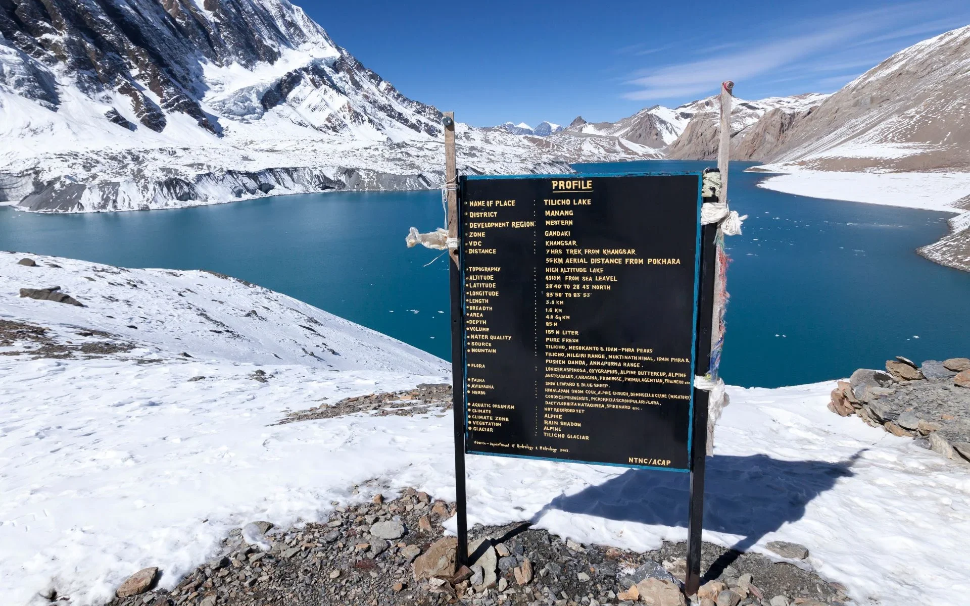
Tilicho Lake is associated with the Annapurna Circuit but is a side route rather than a mandatory part of the main circuit. It branches from the main trail near Manang and adds several days plus a demanding high-altitude detour to one of the highest lakes in the world.
Trekkers add it for the dramatic scenery and the challenge. On our packages, Tilicho Lake is offered as a separate Annapurna Circuit plus Tilicho Lake itinerary rather than being part of the standard route.
How Long Is the Annapurna Circuit Route?
There isn't one fixed distance for the circuit today. Road sections reduce the total walking distance, and different start and end points create different totals. The traditional full walk ran well over 200 kilometers, but modern itineraries that drive to Dharapani and transport out of Jomsom cover considerably less on foot.
Check your specific package for the walking distance, since it depends entirely on how much of the route uses road transport.
Which Direction Does the Annapurna Circuit Route Follow?
The standard direction runs counter-clockwise: Marsyangdi Valley → Manang → Thorong La → Mustang → Kali Gandaki. This direction is strongly preferred because it allows a gradual, safe elevation gain toward the pass and a manageable descent on the far side.
You can technically trek it in reverse, but climbing Thorong La from the Muktinath side means a much steeper, faster ascent with far less acclimatization built in. That direction increases altitude sickness risk significantly, which is why almost everyone walks it counter-clockwise.
Annapurna Circuit Route vs Annapurna Base Camp Route
These two treks are often confused, but their route shapes are completely different.
Feature | Annapurna Circuit | Annapurna Base Camp |
Route type | Circuit | Out-and-back |
Main region | Annapurna + Mustang | Annapurna Sanctuary |
Highest point | Thorong La – 5,416 m | ABC – ~4,130 m |
Main landscape | Highly varied | Mountain sanctuary |
Route shape | Circuit | In-and-out |
If the enclosed amphitheater of peaks appeals to you more than a long loop, take a look at the Annapurna Base Camp route map for comparison.
A Few Practical Route Notes
On the trail, ATMs disappear past Jomsom, so carry enough Nepalese Rupees (NPR) in cash. Expect trail upcharges of roughly 200 to 700 NPR per service for charging power banks, gas-heated hot showers, and Wi-Fi. Ncell gives strong coverage across most of the circuit, and skipping bottled water in favor of a reusable bottle with a filter keeps the route clean.
When passing mani walls, stupas, and chortens, always walk clockwise so the structure stays on your right. Stick to Dal Bhat and fresh carbohydrates for clean, high-energy fuel with free refills. To pack correctly, use our Annapurna Circuit packing list, and to budget accurately, see the cost and budget guide.
FAQs
1. Where does the Annapurna Circuit Trek start?
On current itineraries, the trek starts at Dharapani (1,860 m) after a drive from Kathmandu through Besisahar. Traditionally the walk began at Besisahar itself, but roads now allow vehicle access to Dharapani, making it the practical trekking start point.
2. Where does the Annapurna Circuit Trek end?
Most modern itineraries end at Jomsom, followed by road or air transport to Pokhara. The exact endpoint varies depending on whether trekkers continue walking through Lower Mustang or transfer by jeep or flight.
3. What is the highest point on the Annapurna Circuit?
The highest point is Thorong La Pass at 5,416 meters, crossed between Thorong Phedi and Muktinath. It is the single most demanding day of the trek due to altitude and elevation gain.
4. Is Tilicho Lake part of the Annapurna Circuit?
Tilicho Lake is a side route that branches from the main circuit near Manang, not a mandatory part of the standard route. It is usually offered as a separate extended Annapurna Circuit plus Tilicho Lake itinerary.
5. Can you still trek the Annapurna Circuit because of the roads?
Yes. Roads have reached lower sections and parts of the Mustang side, but the high-mountain route over Thorong La remains a walking trail. Trekkers use NATT walking trails and route variations to avoid dusty jeep roads.